It came as a shock – quite literally. It shouldn’t have, because a recent paper had predicted that the area was preparing for a large earthquake. On 29 July, at 23:25 UTC, the 5th largest earthquake from modern measurements hit the Kamchatka peninsula with a reported magnitude of M8.8. (It is listed as occuring on July 30. This is because the UK is currently on summer time and has moved the clock forward by 1 hour compared to UTC. This moved the quake into the next day.)
This event was large enough to trigger Pacific-wide tsunami alerts. In the end, it ended relatively well. The earthquake caused damage, and so did the tsunami along Kamchatka itself. Further afield the waves were smaller than had been feared. A 2-meter high wave should not be underestimated: it is similar to the Hunga Tonga tsunami when it reached South America where it did cause casualties. This height was measured in Hawai’i. The American west coast came off lightly. It raised the question, how could such a large event not do more? And it has a risk: in the future, people might think that similar sized events are not dangerous and disregard warnings. So we do need to find out.


The location of the segment of the fault that failed is show above, taken from USGS. The aftershocks are currently confined to the indicated red region, as expected. The damage is likely greatest at the city of Petropavlovsk (‘Peter Paul town’), with around 150,000 people. However, this is an important navy base and it is unlikely that Russia will provide a detailed damage assessment, or at least a complete one. Some damage to the nuclear submarine base is visible on satellite images but the level of damage is not known. This is most likely caused by the tsunami. The city is on a bay which is mostly shielded from the Pacific ocean which will have helped. Apart from this city, the region directly affected by the earthquake and tsunami is very sparsely populated.
A plausible explanation for the smaller tsunami is that this earthquake was somewhat deeper than others. The main shock occurred at a depth of 35 km, and the aftershocks too focus at a this depth. In comparison, the 2004 earthquake was at 30 km and the 2011 one at 25 km depth. Shallower earthquakes have larger impacts at the surface, so a deeper earthquake is good, sorry, better news. It should be noted that those earthquakes were also considerably larger than the 2025 Kamchatka one, at M 9.2-9.3 and M 9.0. The Kamchatka earthquake also occured close to low tide which will have helped. (It was also around neap tide, so the earthquake hit at a ‘good’ time.)
Tsunamis are tricky beasts. They are caused by the fast uplift or downlift of the ocean floor after the megathrust earthquake. In fact, any water displacement will do. In Hunga Tonga, the explosion itself caused much of the tsunami, with added effects of the underwater debris flows and at large distance, the atmospheric pressure wave from the eruption. Flank collapses can also be a major cause of tsunamis, as in the 2018 collapse of Anak Krakatau. These are particular dangerous because the wave comes to the coast so fast. But the ones we remember are the devastating events after the 2004 and 2011 earthquakes.
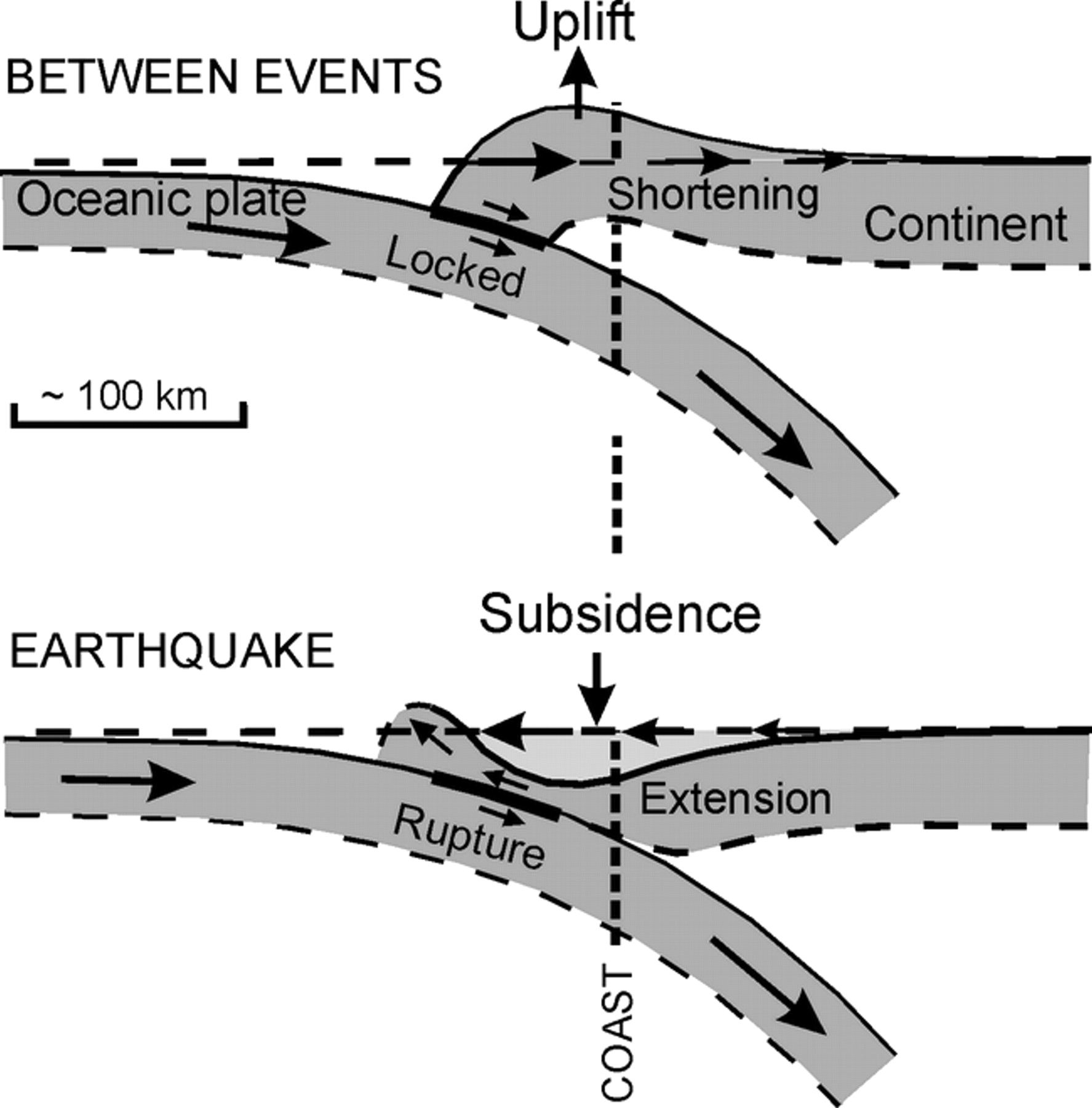
As a reminder, a megathrust earthquake (not to be confused with a maga thrust) occurs when a subduction zone has been sticking and gives way. The subducting plate moves at a constant speed, being pulled down into the mantle. In an ideal case, the continental crust above is well lubricated and the subduction slides smoothly. In reality. It doesn’t: the interface is rough and causes friction, especially at depths between 20 and 35 km where the crust is still cold but the weight of the crust amplifies the friction.

So the continental plate sticks and is pulled down with the subducting plate. The stuck crust is pushing against the adjacent crust, and pushes it up – it has nowhere else to go. This occurs near the coast, and is why in such regions the sea level appears to go down over the years – the coast is rising. This is clearly seen in places such as the Pacific northwest where the trees that drowned in the last major event have been lifted back up above water.

Friction has a mind of its own. Once the stress becomes too much, it suddenly gives up and goes away. The stuck crust now moves back to where it would have been, forward and up. This is the earthquake: the change happens over seconds to minutes. At the same time (slightly slower) the uplifted crust goes down to where it should have been, to the surprise of anyone who built their house on the newly dry land – the sea comes back to claim it. After the earthquake, there is a long period of time (centuries is typical) where the crust sticks and the land slowly goes back to where it was before the earthquake.

The tsunami is caused by the movement of the seafloor which can be 10 meters or more. It displaces a lot of water, and displaced water causes waves. The coast is affected worse because at the same time it went down, aiding the incoming water. The water piles up against the coast: the run-up height can be considerably higher than the wave height just off the coast. Run-up heights of over 30 meters have been recorded. If you live on the coast in a subduction zone, it is best to take a house that is well above this level. Of course, it should also be earthquake proof and not in an area where a landslip could bring both the mountain and the house down. It may be better to live somewhere else.
But why does one earthquake cause a much higher tsunami than another one? The size of the earthquake is one aspect. This depends on the amount of displacement (5 to 10 meter is typical for such events), and the length and width of the rupture zone. But the height of the tsunami is determined by the amount of uplift at the seafloor. For deeper earthquakes the effect are damped by the overlying crust. For shallow ones it is likely that the faults directly reach the sea floor. The angle of subduction may also have an effect but this is less clear. Note that the height of a tsunami is also less dependent on the length of the rupture zone, at least nearby the subduction zone.
And there is something funny here. The 2011 Japan earthquake had a long recurrence time, of many centuries. But the 2025 earthquake followed on from one in 1952 at almost the same location, and before that one in 1923 a little further north. That is quite a short recurrence time.
In Kamchatka, the subducting plate is from the Pacific, and the speed of the plate is 8 to 9 cm per year, straight at the coast. This is high. The subduction zone is also very long, stretching from Japan to the Aleutian arc. An earthquake this size will have ruptured over a length of some 400 km, but that is only a fraction of the total length. Both effects play a role in the frequency of the megathrust earthquakes in this region. In fact, the 2011 earthquake was on the other end of the same subduction zone. It has history. The whole arc has had many M8 earthquakes over the past century. For some reason, they are rather common here.

Historical large earthquakes in this area. Source: USGS.
Before this period, earthquakes of M9.0 or larger occurred in the 2025/1952 rupture zones in 1737 and 1841. Both caused very large tsunamis.
1952
On November 5, a M9.0 earthquake hit the area from Kamchatka to Sakhalin. It caused a devastating tsunami. Over 2000 people were killed in the fishing town of Severo Kurilsk, on one of the islands that had only just been occupied by Russia. The Russian newspapers did not report the event and the scale of the disaster only became known after 2000.
https://www.rbth.com/history/334422-severo-kurilsk-disaster-1952
The epicentre of the 1952 quake was almost identical to that of 2025. But the impacts were much larger. Why was that? And how can the region already have been primed for a repeat, seemingly decades too early?
The details of the 1952 earthquake are uncertain, though, perhaps surprising for one of the major earthquakes of the century. The size is not well determined, and the epicentre and the length of the rupture zone are also uncertain. Estimates for the magnitude range from 8.8 to 9.4! (The high number is not well supported, though.) Currently, magnitude 8.9 or 9.0 is normally quoted. Modeling of the tsunami suggests that the event was not single rupture but that it broke a number of separate segments, each with a different amount of slip and depth. The average slip was 5 meters but some areas had as much as 10 meters. The most recent analysis suggests that the slip was larger and shallower in the south, and less so at the northern end of the rupture zone. That would mean that the epicentre is actually not the best point to locate the 1952 event: it was centred more at the southern end of Kamchatka.

Since 1900, there have been four massive earthquakes in this region of southern Kamchatka. The indication that again something was brewing came last year. Following an M7 earthquake in the region on 17 August 2024, it was noted that the aftershocks were lacking in a region north of that event. Looking at older earthquakes, they too were missing from this area. That indicated that the region was locked, without seismic slip. From this, Kopnichev & Sokolova predicted that the region was heading for a large event, for which they calculated an expected magnitude of 8.6+-0.2. As indeed happened. They had predicted an epicentre further north, by about 50 km, from the real epicentre, but we can give them that.
This may be the first case of an accurate prediction of a major earthquake! You can read all about it in their paper at https://link.springer.com/article/10.1134/S1069351325700193 – or at least you could have had the publication not been hidden behind a paywall. That is something it has in common with the paper predicting the collapse of Anak Krakatau. These paywalls are not only affecting scientific progress, they are now doing damage in the real world.
All this suggests that the 2025 earthquake was not a copy of the 1952 one. It’s main effects were further north, and it filled in gap of partial rupture between the 1952 and the 1923 earthquakes. If indeed it was a bit deeper than the southern part of the 1952 rupture, that may help explain the smaller tsunami.
Volcanoes
The first person to note a relation between large earthquakes and volcanic eruptions was a guy named Charles Darwin – you may have heard of him. On his long journey on the Beagle, he had found himself in Chile during the M8 earthquake in Concepcion. Darwin wrote that after the earthquake, four Chilean volcanoes erupted. This has perhaps not been given the attention it deserved. Landslides can of course cause dust clouds which may give the impression of an eruption, and the volcanoes may also already have erupting. But there has indeed been a discussion on whether earthquakes can trigger eruptions.
The 2025 Kamchatka eruption has settled this discussion. Kamchatka is rather volcanic, and it is a perfect location to show the effect. First, Kliuchevskaya Sopka’s on-going eruption intensified after the earthquake. This may have been coincidental, but it could easily be a direct consequence, either from increasing gas pressure in the magma due to the shaking, or from faulting near the erupting summit. Then, Krasheninnikov erupted, with its first explosion for 400 years. That is no longer a coincidence and the quest will be on to find out exactly how this eruption was caused. It is fair to assume that a volcano should already be able to do an eruption, for an earthquake to have an effect. But in a place like Kamchatka, that leaves plenty of candidates.
Both volcanoes are a bit north of the likely rupture 2025 zone. But it is possible this zone extended further north than currently known, and in any case, they aer close enough to have undergone significant deep shaking.
But there is another case which has not been given attention. A few years after the 1952 event, the volcano Bezymianny woke up after a 1000-year slumber. The unrest began in 1955 and in March 1956, it suffered a flank explosion reaching VEI 5. Ever since, this has been one of the more active volcanoes in the world. But it was deeply dormant before and was even considered extinct. It lives close to Krasheninnikov. Coincidence? Perhaps not.

The March30 1956 eruption of Bezymianny Volcano. Photo by IV Yerov
Other cases of earthquakes preceding eruptions have been suggested. Volcanic activation cannot cause major earthquakes: M5, perhaps M6 is about the most it can cause. Anything more requires tectonic events. The large eruption of Vesuvius was preceded by a damaging earthquake, 17 years before the explosion. Vesuvius was near-extinct at the time. The 19th century eruption of Krakatau followed some 5 years after a major earthquake. But in all such cases, proving a link is elusive. All these volcanoes exist in major earthquake zones where large events are frequent, although for Vesuvius large earthquakes are not that common. But given the 2025 events, Bezymianny is worth another look. Perhaps the shaking did wake up this sleeping giant.
And this is the story of Kamchatka 2025. The damage seems limited and the tsunami was smaller than expected: something to be grateful for. But we have a lot to learn.
And the bottom line: if you want to warn people about an impending disaster, don’t do it behind a paywall. Those paywalls are there to stop people from reading the work, and in this they are quite effective. You risk becoming a voice crying in the publishing wilderness.
Albert, August 2025


To the users who use the comment section, please don’t use questionable Russian links or photographs anymore since the anti-virus blocks the entire page content.
I guess that dome collapses would be the most likely reason for an eruption after such a major earthquake. Literally shaking the dome apart! Then once the cork has popped off the champagne sprays out.
Very good, as always, Albert.
I remember the huge earthquake in Valdivia, Chile. I was a kid then, it been said there were “several”volcanic eruptions as a consequence – which appeared in my children’s drawings: earthquke, tsunami, volcanoes and all. My father, a civil engineer who was very fond of Geology didn’t contradict the fact.
I remember having heard about Cordon Caulle as one of these volcanoes and again after the last big Chilean earthquake: 2011 perhaps?
Food for thought!
Wasn’t long-dormant Chaiten thought to have awakened following mega-thrust activity off Chile?
Kilauea 1975…
Now that you mention it, Kilauea in 1868, too, making it a repeat offender. Both times were summit dike intrusions triggered by M 7.7+ earthquakes.
“The American west coast came off lightly, although it was reported that it was still the highest tsunami wave there on modern record”.
Just to clarify, the tsunami was not nearly the highest on the NW/California west coast in recent times. For the M8.8, the highest wave measured was in Crescent City (NW Calif. coast) at ~ 7′ and caused an estimated $1M in damage…however that is well below the great Alaska 1964 quake/tsunami that crippled Crescent City from a ~21′ wave that killed 11 and did 10’s millions of dollars damage.
Since 1933, there have been somewhere between 34 and 41 tsunami’s (due to data uncertainty), of which 6 caused damage. The 1964 tsunami, by far the largest, was extra deadly since the big wave was the 4th to hit with the previous 3 much lower. After the 3rd wave, which was the lowest of the first three, people mistakenly went back into the flooded zone, then got nailed with the big wave with nowhere to escape. In all, 286 buildings were destroyed and the entire downtown had to be rebuilt. Elsewhere, like at my old home in Pacifica on the coast just south of San Francisco, our local “bay”, Linda Mar (actually just one of several large coves that line the coastline) completely drained prior to what was estimated a 7′ wave swamped the coast.
But note, Crescent City’s 7′ wave was the exception with this last tsunami, with heights elsewhere along the coast generally under 1-3′ which did little other damage..so significantly less impactful than the 4-7′ tsunami from the 2011 Tohoku event that did an estimated $100-$125M in damage to several ports up and down the coast.
Those of us who were/are Grateful Dead fans used to quip about “if the quake don’t get ya’ then the big-wave will”.
Sadly, it could/will happen again.
Thanks for that. I was looking for the facts behind that media statement but ran out of time!
Another thought on the apparent weaker tsunami from the M8.8..is it possible that acceleration played a role? (I tried finding the max G-force, but so far nothing has been reported that I can find).
Due to the deeper slip zone, maybe the surface elevation changed more slowly? In theory, if it took an hour for the ground to finish moving in a large quake, I would think that a very small tsunami with a huge wavelength would get generated..however if the sea-floor lurched upwards in a matter of seconds (or a minute or two), a larger wave would get generated, even though in the end the sea-floor changed elevation by the same amount for either quake??
I’d refer also to the eruption of Pinatubo as a case of correlation – although not necessarily causation; there had been a M7.8 earthquake a few months earlier IIRC.
And yes, one theory is that the tsunami from the recent quake was smaller than it could have been due to the main area of slip being deeper. Apologies, I’ve been rather busy with the tsunami response!
Yes, correlation and causation are different things! You would need a lot of data on dormant volcanoes and the chance of a new eruption, and then whether this chance is higher after a major earthquake in the vicinity (and how far?). At the moment we can say no more than that it is ‘suggestive’. The case for earthquakes triggering instant eruptions in active volcanoes is now strong, but for dormant volcanoes we need a few more centuries of data!
JMA has raised the alert level at Kusatsu-Shirane due to an increase in volcanic tremors.
https://www.jma.go.jp/jma/press/2508/04a/Kusatsu-Shiranesan_20250804.pdf
This alert is specifically for the Yugama vent, not the Motoshirane-san vent that unexpectedly formed during the last eruption.
The 1952 Kamchatka earthquake should have settled the case already, with eruptions of Karpinsky (the same day) and Tao-Rusyr (7 days after). For both volcanoes, these eruptions are the only historical events; nothing before the earthquake, nothing after… The 1960 eruption of Cordón Caulle is also often cited as having been caused by the Valdivia megathrust earthquake 2 days before.
I didn’t know about those! Of course, with Russia denying the existence of the earthquake, reporting was pretty limited. Tao-Rusyr is listed as only having had two eruptions since the caldera eruption, but that seems inconsistent with the appearance of the new cone. There must be many more eruptions which build the 1-km tall cone
1956 Bezymianny showed that there can be longterm effects of megathrust (not megacrust) quakes. The causal relation doesn’t has to be directly, but can be mediated by a chain of events or by side-effects.
Here is a USGS map with Kamchatka’s volcanoes:
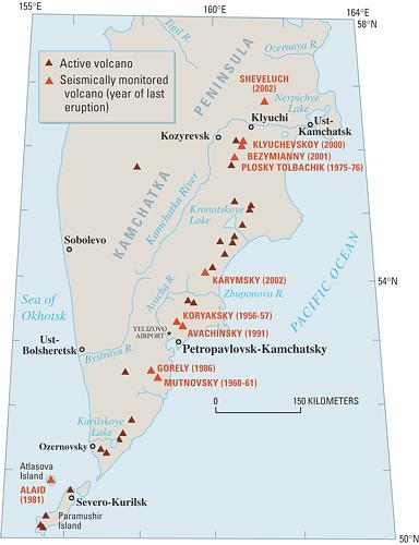
https://pubs.usgs.gov/fs/2002/fs064-02/
Thanks again for your work Albert. It’s great that nowadays we have early-warning systems.
Re: “Lakigigar
03/08/2025 at 22:57
To the users who use the comment section, please don’t use questionable Russian links or photographs anymore since the anti-virus blocks the entire page content.”
Quite right too, but I’m thinking, here we go again. Politics and religion block the benefits of science. Or even murder scientists when truth is unpalatable.
😒
Kilauea starting with small lava flow.
Finished few moments later.
Its interesting how the tilt has gone down a bit again, like the elevation of the vent now is at a point the existing lava geyser system is failing to keep its rhythm. The episodes now might have to be significantly further apart, and maybe not so predictable on the tiltmeter on shorter timescales.
It is interesting that the elevation of the vent now is probably about the same as the old 2018 lava lake, about 1030 meters by my guess but maybe as much as 1050 its hard to say and HVO hasnt given that detail. This point is enough to erupt anywhere else on the volcano, so if neither rift zone becomes active in the next year or so it is much more likely we really are looking at a new summit overflow period beginning, like happened in 1200-1450.
I guess now is a potential that some other major change could occur too, although nothing is obviously in the making yet.
There appears to be a large seismic gap, just northwest of the word Kuril on the Historical Earthquakes map.
You spotted it. It may be that this region ruptured in 1952. There is also an apparent gap further south where the last M8 was in the 1950’s
Japan Gov’t (I assume the JMA?) gives the area off Hokkaido (Nemuro) an 80% chance of a major M7.8-M8.5 in the next 30 yrs. That’s the seismic gap of most concern IMHO.
If there indeed has been stress transfer from the M8.8 (as evidenced by a brief flurry of moderate quakes ESE of Hokkaido following the M8.8). the added stress is coupling to a section of fault already on the brink of letting loose.
https://i.imgur.com/QLu0eda.jpeg
Recently (last month or two?) there was a cluster of M5.0-6.0 earthquakes off the east coast of Hokkaido. Any chance they’re related?
That’s the million dollar question. There’s a lot of stored energy there, and it’s going to get released…only question is the timing.
https://www.vedur.is/gogn/myndir/webcam/2025/mm/yy/webcam_fagridalur-W.html#
(Replace mm/dd with todays date in Iceland)
Going through the images, especially at night its actially possible to see glowing and persistent fume sources on the right side of the image, it looks like a real lava tube has formed going north. I havent seen any images or new pictures of the end if the flow field but it was advancing north along the edge of the lava field formed last August, as slow pahoehoe spreading like a geological slime mold over the moss. Presumably its got a fair way further if that is the only active bit far from the vent, though probably not past the end of the 2024 flow yet.
it might be done now, or preparing for a pulse tho im pessimistic
Tremor dropped back to background levels after noon yesterday, so there’s currently no fountaining inside the crater. There were some darker, brownish emissions from the crater between 6AM-8AM this morning, indicating that it’s still doing something. Before the tremor dropped, there was a 36h period of stronger activity, so there is a possibility it has entered a pulsating eruption style, like Fagradalsfjall 2021, but more likely it’s just shutting down. It’s a bit too soon to call it over just yet, but I believe the chances that it resumes are small.
eruption been declared over by imo today, aaand the next wait begins
https://agupubs.onlinelibrary.wiley.com/doi/10.1029/2022GC010811
Intresting paper
https://m.youtube.com/watch?v=6IaMqotNF_s&pp=ygUOa2lsYXVlYSB3ZWJjYW3SBwkJxwkBhyohjO8%3D
Whats this background sound? gas jetting from the vent or just ambient background noise thats blown up more so we can hear it ?
as far as i know, afartv puts random audio in the background that isnt live or probably even recorded in hawaii.
Its from 2021 at Fagradalsfjall, I think. Otherwise it is just a recording of the wind somewhere else.
It’s just random soothing noise that afar.tv added to the video, the original video doesn’t have any audio.
“Southern Kamchatka shifted 2 m (6.6 feet) during M8.8 earthquake on July 29, 2025”:
https://watchers.news/2025/08/05/southern-kamchatka-shifted-2-m-during-m8-8-earthquake-july-29-2025/
There were reports that some mega quakes even shifted the Earth’s Axis a bit. F.e. 2011 the Fukushyma earthquake shifted the Earth’s Axis by 17cm.
Pingback: Mw = 8.6 ± 0.2 – Zoopraxiscope
Message from HVO:
Kilauea Message 2025-08-05 08:51:55 HST
A helicopter overflight of the north vent this morning confirmed that lava is within 15-30 feet (5-10 meters) of the top of the vent. The lava is degassed and is feeding a low volume into a lava tube inside of older flows in the crater.
Looks like Ep. 30 is getting close…
I wonder if those lava tubes are actually one of the satellite vents tbat formed in E29. I was earlier skeptical of it becoming an open lava lake but recent days have maybe changed that chance. Although I still think it has a long way to go before it becomes truely steady state continuous effusion it isnt unlikely we have seen the peak fountain height.
Of course now we will see 500 meters tomorrow 🙂
This article might be worth discussion https://en.wikipedia.org/wiki/1737_Kamchatka_earthquake
Mutnovsky was raised to level 2 (yellow) yesterday also.
The Sun claims 6 volcanoes in Kamchatka going off now https://www.the-sun.com/news/14905714/ring-of-fire-third-volcano-eruption-russia-fears/
Quite hyperbolic. 2 of the named are still dormant with only increased degassing noticed at Avachinsky, nothing mentioned about any changes at Mutnovsky as far as I can tell and with the exception of Krasheninnikov all of the rest were already erupting before the earthquake..
But then again isn’t The Sun infamous for being rubbish?
Found this interesting:
https://watchers.news/2025/07/27/early-subduction-zone-british-columbia-earthquake-risk-revealed/
Similar is seen along the Indian/Burma collision.
I just came across this too, missing quakes, https://www.bbc.com/news/science-environment-25329813
Earthquakes appeared on the west end of this subduction segment near Japan’s Honshu island: https://earthquake.usgs.gov/earthquakes/eventpage/us6000qyhb/executive
Episode 30 started from the hole in the caldera wall
That was very unexpected. New vents appearing on the south wall? Looks pretty like this is going to be unique to see…
Its a fissure too, so there was actuually a new dike intruded. Its unclear if it is original from the magma chamber or from the existing conduit (meaning it is a satellite of it) but this is something I said might happen based on how Pu’u O’o behaved.
It started FAST though. Not even an hour ago as I write this and already flooded probably at least 1/3 of Halemaumau. And there was no real buildup, just the same bright glow of the past day, then it overflowed and it all went up to full power in under 15 min. No high fountains again it looks like.
On that note, 3 earthquakes were detected before then, something that has never happened since the earliest episodes.
The seismometer, as expected, is way out of scale. But the clear signal of an intrusion is there before the tremor.
So basically, Kilauea has started E30, but the south wall fissure is probably an entirely independant eruption of its own, and its not unlikely that had the existing vent been blocked the entire south caldera platform would be a curtain of fire now… 🙂
Like 1954 in some respects.
On that same note the “south” vent (no longer the southernmost vent) has reactivated. Maybe there was too much pressure for one vent or a close cluster to handle…
This is the shield/cone from yesterday before Ep. 30 happened.
Tilt at SDH, it spiked vertical right as the episode began, and there are strong quakes in the south caldera area. Seems there was most certainly a dike intruded into the south caldera fault and it has erupted through the wall and could even still surface outside Halemaumau, even while the existing vents both started up as expected and at least as strong as last time
Because of the intrusion the volume may end up less than E29 but at the same time the intensity is very high, EpicLava has a live going at Keanakako’i and the new fissure is a full curtain of fire in its own right, nevermind the main vent.
5.5 microradians dropped in under 1.5 hours. E29 was 6.7 million m3 erupted to drop 19 microrads, so currently the amount of magma drained from the summit is probably about 2 million m3, or close to 400 m3/s.
Its going to be over in 3 hours at this rate…
Looks like the new fissure and pre-existing vents are far apart. I wonder if the fissure is erupting close to the area of the July 2023 cone…
Basically exact same place but further up the cliff. Probably a coincidence, this was tbe lowest spot above the dike, but still.
No reading yet on MIROVA, but I suspect it is going to dwarf the 1-4 GW readings of Klyuchevskoy and Nyamuragira. E29 read close to 12 GW, and this has a whole extra vent which is where the heat is most intense…
(B1 cam, live)
Looks like the lava from the southern fissures already reached the lava plain from Ep. 29. If this continues for another few hours, it could inundate the area with lava, raising the floor.
Yes, it looks like a small Halema’uma’u dike intrusion triggered this episode, it doesn’t look like there are any more earthquakes or at least the seismometers don’t show them and tilt show the deflation expected from an episode, so it doesn’t look like the dike is continuing or has reached beyond the caldera. The fountains are very low again and initiating geyser mode was so difficult that a dike formed instead, I think we may be seeing the end of the high fountain stage, and that the eruption is reaching a tipping point, it might transition to continuous effusion or intrude the SWRZ, or deflect magma flow elsewhere. The return of the DI events is also interesting and makes me wonder if it’s related to the recent changes.
Technically, it is still geysering, but just tilted at a different angle. Maybe the slump had an affect on the way lava shoots out.
This is from yesterday and the blurring might be the vent underneath the overhang. Maybe that was the obstruction causing it to point the other way, though this didn’t contributed much to the new activity seen now.
The southern short fissure was in the area, where 2023 was a “vent in the cliff”. Maybe this path was reactivated somehow.
Maybe, I think its more likely just a weak area that is easy to intrude though. I guess we need to wait for E31 to see if this was a unique event or if things really are starting to break down. Its not unlikely that high fountaining resumes, the main reason preventing it in E29/30 seems to be the cone slumped over and has deflected the vent off vertical, but that isnt permanent by any means.
Regarding future fissures though, the far east end of the caldera has had occasional quakes, and possibly the SWRZ connector, so the whole south caldera area and even a bit beyond could be viable. Surprisingly, nothing on the shallow SWRZ cracks that fed 1919 and 1971, but maybe we shouldnt expect earthquakes here anyway.
Both the 2023 vent and the main eruption cones 2025 are in the caldera wall. Also the shortterm SW fissure of Episode 30 was in the cliff. Does the cliff belong to the Caldera Rim Fault? Can we expect more Calder Rim Fault vents to occur?
Its pretty likely there would have been a full ring fault eruption if the main vents were blocked, the dike was probably only 100 meters below ground in the 1982 vent area, but because it erupted in the wall lower down and the main vent got very active the pressure was removed and the dike stopped.
But, yes its likely to become active again. Pu’u O’o had flank fissures open frequently in its fountaining days and these were very often in the same places. As the caldera floor rises it only becomes more likely that more vents open and outside the caldera at times. The bit that is important is if the new fissure is a satellite of the existing vent or did it intrude out of the magma chamber directly and is therefor a second eruption technically. I am going on the latter, the fissure had no real affect on the north vent at all like a parasitic satellite would be expected to.
I dont think the main vents will die though. It actually looks like they could be merging, the north vent fountain is clearly deflected and is sourced under its south rim, otherwise it would have been much higher. Tall fountaining isnt dying off there is just an obstruction, which will likely fail soon.
The new vent is about done for.
Looking at the V3 camera, it seems some lava has drained back into the fissures as the formed this bathtub ring. Also, the south fussure is no longer active.
Nice pictures in here of Krashennikov which erupted two dazs ago after a dormant interval of 500 years:
https://www.livescience.com/planet-earth/volcanos/dormant-volcano-erupts-in-russia-for-first-time-in-around-500-years-days-after-magnitude-8-8-megaquake
Plus multiple quakes today Kamtchatka and Kuril Islands between 4.7. and 5.8, depth between 10 and 31 km, Kuril Islands 60 km.
Albert, you had the eruption already, had not gotten there yet. This is funny: “It lives close to Krasheninnikov.” (Albert speaking of Bezymianny which erupted in 1952). Yes, for us they are certainly living creatures with a soul.
Concerning the moderate tsunami it might play a role? that the epicentre was close to the coast. The 2004 Sumatra earthquake was also at a depth of 30 km, but 1. had a magnitude over 9, possibly 9,2/ 9,3 and 2. was at a distance of 160 km from the coast.
It is so close geographically that I believe there must be a connection. Why should a subducting plate getting stuck not shift the whole system and move magma in a former island arc which is now a peninsula? I wonder whether there is any other region on earth where volcanoes sit so close to the subduction zone. Ideas?
The subduction arc has moved outwards towards the pacific over time, as the Eurasian/Okhotsk plate overrides and is pulled over the Pacific plate. Subduction has been going on there for a long long time and Kamchatka itself will have undergone extension also. Warm buoyant oceanic lithosphere will generally mean a closer subduction front. The trench is still 200km away from the volcanoes though.
https://earthjay.com/earthquakes/20150131_bering_sea/Volcanism%20and%20Subduction%20%20The%20Kamchatka%20Region.html
There we go, double extreme rating.
https://i.imgur.com/vi2NbJY.jpeg
13 GW heat emission.
https://www.mirovaweb.it/NRT/index.php shows 24.93752 gigaWatts for Kilauea, so did they combine the 2?
No that is a single value, that number is insane for an area of only about 3 km2, 8 GW per km2.
Basically every reading is a moment capture of thermal emission at that point. It may or may not also record wildfires but I assume that is filtered out on this page.
With Kilauea’s episode 30 behind us, I thought it’d be a good time to share an update to the episode graph. I did similar at the close of episode 25.

The most notable change since episode 25 is the exponential growth in lava effusion. The maximum _average_ effusion rate, however, seems to cap out in the neighborhood of 200 m³/s. Still a lot, but for now it seems to have hit the ceiling. On the tilt graphs, however, it’s obvious the maximum rate of an episode lies much, much higher – I’d wager around 400 m³/s if not more. I suppose not much else can be expected from a dominant north vent acting like a sprinter – explosive start but fizzles out as time progresses, opposed to south vent which acts like a marathon runner – slow start but remains constant until the end.
Statistics of episodes 26 to 30, as gotten by pixel-counting UWD and rounded to one decimal:
* E26: 5.0 million m³ recharged ahead at 7.1 m³/s on average | 6.3 million m³ effused during at 200.2 m³/s on average
* E27: 5.6 million m³ @ 7.3 m³/s | 5.7 million m³ @ 127.5 m³/s
* E28: 6.1 million m³ @ 7.5 m³/s | 5.7 million m³ @ 175.3 m³/s
* E29: 6.8 million m³ @ 7.4 m³/s | 7.3 million m³ @ 142.4 m³/s
* E30: 8.1 million m³ @ 5.7 m³/s | 8.8 million m³ @ 203.3 m³/s
Another thing I found interesting, is that the recharge rate ahead of episode 30 still averaged at 5.7 m³/s, despite the two D/I cycles which occurred. The previous instance (ahead of episode 23) resulted in the lowest recharge rate of the entire eruption so far, at only 3.4 m³/s.
Thing is, the pressure this time was high enough that the standard episode occurred but there was still enough extra to create a new dike, which kept erupting for 3 hours even after the main vent got up to full power.
It also looks like the new dike was entirely intruded basically in about 20 minutes as the north vent overflowed but didnt fountain yet. Fountaining at all vents started pretty much the same time. The fact SDH moved probably means it went at least into the area of the 1982 vents, the next insar will be interesting. It also means an eruption in this area is a likely occurrence at some point, maybe even in E31 if the dike is still viable and especially if the new fissure reactivates too.
I just noticed this, HVO has put up the entire tilt record of the eruption, live updating too 🙂
E30 started with the highest tilt since E4, which was the last episode to have pre-existing overpressure from before the eruption. The tilt has been generally very level but it has gone up slowly, though possibly more on average recently.
Summaries of the episode:
https://www.youtube.com/watch?v=wJId-KyMhdE
https://www.usgs.gov/observatories/hvo/news/photo-video-chronology-august-6-2025-episode-30-kilauea-summit
Pu’u O’o did 44 episodes in three years. They lasted longer than the current summit episodes.
Longer but also further apart, usually at least a month and I think over 70 days was the longest gap. High fountaining stage of Pu’u O’o erupted something like 0.4 km3,in 3.5 years, about 0.12 km3 a year. The current eruption now is 2/3 of a year old and now probably over 0.14 km3, most likely over 0.2 km3 by years end.
August 1983 only had one single episode in the 3rd week! It lasted for two days (15-17 August). The lava fountains of this 7th episode were 50m high, so not much different to the 30th episode of August 2025.
The 7th episode had a volume of 14 million cubic m and a rate of 250,000 cubic m per hour.
https://www.soest.hawaii.edu/GG/HCV/puuoo-episodes.html
Episode 30 did 200 cubic m per second, while Pu’u O’O Episode 7 did 69 per second. E30’s rate was 2.9 times stronger than Pu’u O’o 7.
Part of that is Pu’u O’o was tapping tge main magma plumbing, not only Halemaumau, and in 1983 was also 300 meters lower than the floor of Halemaumau. So while not as strong as in tbe lower ERZ there is an element of gravity draining,and Pu’u O’o caused significant net deflation that only reversed in the 2000s as supply increased faster than the eruption rate. Heiheiahulu further east is also a lavashield but it looks like it is just a late pahiehoe stage of a much larger probably long lived episodic eruption, possibly with even larger and more separated episodes than Pu’u O’o. The description of many flows inundating Kaimu in the 1750s has been taken as many separate eruptions over a timespan but could also fit an episodic eruption at that one spot maybe even better.The lower ERZ is almost exclusively just intense fissure eruptions of large scale, though im not sure any are properly episodic.
Really, with this fact in mind, its actually surprising the current eruption is even comparable. 1959 was faster to recover but also drained back all the lava of every episode except 1 and 4, so had very little bet output. There is very little gravity influence,, and none of the extensive rift plumbing, yet at this rate a pause of a month would result in the same volume as at Pu’u O’o using the refill rate for E30, and about 20 million m3 using the refill rate of the 3 prior episodes.
Laguna del maule alert level got raised
Bur ni Telong deep swarm is swallowing and it’s alert level got raised.
Kuju is getting a swarm of sorts.
Very good week!
Any updates on CCN, or Iwo Jima?
Ioto is stable and CCN is still doing pulse-like mini swsrms. Waiting for an report for last month’s activity
hmmm. Interesting. When you say Ioto is stable, is that “There’s no continuing or new activity whatsoever”, or rather “It’s still doing the same activity it always has (i.e. the ground inflation), but nothing new beyond that.”
Thank you for the reply! and keep up the fantastic work!
Thanks! Ioto is doing the typical unrest.
Thanks! Ioto is doing the typical unrest.
Hoping for a new study
Swarm at Abu seems to be restarting as well. Still deep though, curious.
New swarm beginning on the Reykjanes Ridge
A couple of stars too, only just over m3 though.
There have been two swarms: One Wednesday, one today (still running). And the Anti-Reykjanes (Tjörnes Fracture Zone) answers near Kópasker. Are there moments of All-Iceland rifting on small scale?
Can we call the Snaesfellsness earthquakes a low frequency swarm?
Mount Teide recorded a new seismic swarm early this morning, with more than 700 small earthquakes located southwest of Pico Viejo, in Las Cañadas de Tenerife.
The director of the IGN points out that these swarms do not imply a magma intrusion on the island of Tenerife, as occurred in 2021 on La Palma and in 2011 on El Hierro.
Spanish: https://www.lavanguardia.com/local/canarias/20250807/10958068/teide-registra-700-sismos-cinco-horas-ign-vinculada-intrusion-magma.html
English on the same topic: https://watchers.news/2025/08/07/seismic-swarm-more-than-700-low-magnitude-earthquakes-detected-teide-tenerife-august-2025/
Teide can do Phonolite eruptions like Vesuvius and Laacher Sea. Monatana Blanca is a flank volcano which did an explosive eruption with a 15 km high plume. https://en.wikipedia.org/wiki/Monta%C3%B1a_Blanca#Formation
Concerning the relatively meagre tsunami some clues might be won by studying the 1946 Aleutian earthquake which was followed by a massive tsunami.
Whereas we are “spoilt”, sort of by two gigantic tsunamis, 2004 and 2011, back then there was a certain astonishment about the height of the waves. There is a discussion about a submarine landslide as an aggravating factor. So here, near the Siberian coast in question there might not have been an additional landslide.
“At Unimak Island, tsunami run-up reached 42 m (138 ft). The tsunami earthquake aspect of this event helps to explain a portion of this massive height; however, the rest must be attributed to a local submarine landslide” plus
“The wave reached Kauai, Hawaii 4.5 hours after the quake, and Hilo, Hawaii 4.9 hours later. In the Hawaiian Islands 159 people died.”
https://en.wikipedia.org/wiki/1946_Aleutian_Islands_earthquake
https://academic.oup.com/gji/article/165/3/835/555752?login=false
Besides I think the weather must be important. In April there is a statistical probability of bad weather and ice in the water (see collision of oceanliner Titanic with floating ice), whereas the weather in August is statistically better. I am writing statistically as I am not aware of the weather data for both events. Just saying: If the ocean is wild to begin with it might add to the height of waves. Tōhoku was at the beginning of March.
The 1937 Kamtchatka tsunami, described by Russian explorer Stepan Krasheninnikov happened in the middle of October and caused a higher tsunami with 20 m waves on the northern Kuril Islands ans 30 m waves in Avacha Bay.
However, the landslide factor might be more important if we only think of the Storegga Slide although bad weather and submarine landslides should basically be related.
So, this relatively tame tsunami might have been the exception of a rule in the North Pacific.
A comparison between the Dec. 2004 Indian Ocean Erthquake and the March 2005 Indian Ocean Earthquake is equally puzzling as the latter originated in about the same area and only caused a minor tsunami compared to the first.
The latter had a magnitude of “only” 8,6 which is though significantly less than 9,2 to 9,3.
But then it is certainly important what happens on the ocean floor, and the Dec. 2004 quake caused a drastic vertical sudden rise of the ocean floor.
https://en.wikipedia.org/wiki/2005_Nias%E2%80%93Simeulue_earthquake
Corr. 1737 Kamtchatka tsunami. Krasheninnikov was a Russian explorer (1711-1755) who went to school with Lomonosov (1711-1765).
VD published satellite image of Krasheninnikov, it shows kind of a fissure eruption with long lava flows. I didn’t imagine that the volcano would erupt effusively after the long sleep. Was there an injection of basaltic magmas that erupt now? Maybe the mega quake was only the a supporting aid to begin the eruption.
According to GVP the volcano has Basalt to Dacite magmas. “The intra-caldera stratovolcanoes are situated along a NE-SW-trending fissure that has also produced zones of Holocene cinder cones extending 15-20 km beyond the caldera.” Fissure eruptions are common for this volcano, no exception. How can this subduction zone volcano do fissure eruptions?
They usually occur in some sort of linear fracture where some fracturing & extension takes place, if from a large volcano rather than a plume-fed one. So it could just be a zone of weakness, generally speaking it’s easier to push a dike downhill and erupt elsewhere. The same reason the likes of Etna, Cordon-Caulle, Tolbachik etc have them
Edit: There are some cascade volcanoes with fissure systems also
Do the extension zones behave like extremely short failed rift systems? There are large failed rifts in the world, where divergent forces created a graben, but stopped to rip the earth further apart. The North Sea and Oslofjord are two examples for failed rift systems.
Why do zones of extension develop in subduction zones? I understand that in a kink point like f.e. Sunda Strait (between Sumatra and Java) can develop some extension with Krakatau volcano. But this doesn’t apply to all extension zones in subduction zones.
Subduction zone volcanoes can produce fissure eruptions from the flanks, some do so frequently like Ambrym or Tolbachik, or others very rarely, the unusual thing is a volcano that doesn’t have any fissures. It’s just that our classifications and textbooks make it look otherwise, as if it was something that belonged exclusively to Iceland or Hawaii.
Just a throwaway question, but do any (or many) volcanoes right now show signs of radial fissure swarms? There is plenty evidence of this on LIPs of the past, as well as on other planets.
It seems that fissures are usually oriented along a straight line even for mantle plume provinces like Hawaii.
Probably because LIPs on other planets happen through thick crust of most likely more uniform composition than Earths. Venus maybe has some granitic crust, and maybe plate tectonics of some sort when it still had oceans. The Columbia River and Afar LIPs seem to be controlled by their regional tectonics that still behave the same today, with rift zones and not being radial. The truely radial LIPs seem to only exist inside plates that are too big to be fragmented by the event, leading to the same condition as on Venus or Mars.
Hawaii also has a different cause, the weight of the islands is sat on accumulates sediment, and its also likely formed an oil deposit with how much trapped organics are buried, which might further weaken the base. So the island slides.
And because the volcanoes grow through each other they usually slide in one direction, leading to preferred areas of intrusion, and it compounds. But not all the volcanoes have rift zones and the volcanoes with great prominence (which is all of them except Kilauea…) all have radial vents even if they are dominated by rift zones.
Spreading ridges and Kilauea are entirely linear swarms where dikes always follow the same direction. Mauna Loa is mostly linear but has a radial arrangement over the north flank and the distal rift zones. Elsewhere in the world, subduction or intraplate they tend to be a combination of radial and linear, they open in all directions around the summit but have a preferred one that is intruded more often. Etna or Piton de La Fournaise are good examples of volcanoes where dikes are arranged radially.
Thanks. Looks like Wolf also does dikes in all directions from a circumferential fissure after a bit of research
Here HVO wrote 1997, that radial eruptions can occur on the southwest, west and north flank: https://www.usgs.gov/news/volcano-watch-radial-vents-mauna-loas-curve-ball-lava-flow-hazards
Contrary to this Mauna Kea has like Etna many cinder cones distributed all around the summit. This map shows the cinder cones and lava flows of different ages:
 ?itok=Oy9VDrO2
https://www.usgs.gov/media/images/geologic-map-mauna-kea-generalized-surface-distribution
Wow it looks like it is about the same as the andesite at Kilauea in 2018, not super fluid but it is free flowing and still has spattering and fountains. Its at the summit, but the nature of the eruption and presence of large lava flows on the flanks makes it likely to do something similar again at some point.
Thing is, calderas tend to have crystal poor magma, which is less viscous. So this lava could probably be anywhere on its known composition range. It actually might be more likely to be dacite if the magma chamber had any stratification and the earthquake really was the trigger. Glass flows easily at 1000 C with more SiO2 than any natural magma.
The magma had to be hot to run fast like this. The slopes help probably. Google Earth shows that Krasheninnikov is a Somma volcano like Vesuvius. Inside a larger Caldera sits a large twin volcano with two craters. The northern one has erupted with lava (sat image).
GVP says: “Krasheninnikov volcano is comprised of two overlapping stratovolcanoes” So Krasheninnivok consists of two volcanoes! This is different to Vesuvius with one volcano in the somma. The two volcanoes were created in two different cycles of eruptions spanning each over 4,500 resp. 6,500 years. The current cycle has moved back to the northern cone and happens predominantly there. The satellite image confirms the theory that only the northern cone erupts during the current cycle. But flank eruptions are also possible.
Jim Lovell, of Apollo 13 fame, has died
sample analysis is out:
https://jardvis.hi.is/is/fyrstu-nidurstodur-berg-og-jardefnafraedi-sundhnuksgoss-i-juli-2025
Nice data, although my browser’s translation from Icelandic was somewhat idiosyncratic. 😀
From what I see after the end of the current eruption the rate of inflation has now returned to the same as last time. Which suggests magma is upwelling at a steady flow, and we’ll have another episode in a few months.
Three citations from my translation:
“the MgO concentration reflects the cooling and crystallization of the magma, and the K2O/TiO2 ratio shows changes in the composition of basalt that occur deeper. The witch’s hair has the highest concentration of MgO, which reflects how quickly these tiny needles solidified and how crystal-poor they are as a result”
“all glass compositions are slightly more advanced than in tephra formed in the eruption on 1 April 2025 and have a somewhat lower K2O/TiO2 ratio”
Conclusion/Analysis: “there has been no significant change in the magma chamber under Svartsengi and that the magma from July 2025 has not come directly from deeper depths in the earth’s crust.”
According to mogi inflow model it looks as if inflow kinda stabilized after april. After the november eruption it seemed like it could die out soon but after april inflow has been constantly higher on average (compared to february-march)
Yes, I think we see the development of two macro episodes: The 1st macro episode from Novemberg 2023 to End of March 2024. The 2nd macro episode began on April 1st. Each macro episode begins with a major intrusion (sill) with graben formation that is the base of a number of micro episodes. I guess they are influenced by several magma reservoirs that feed each other and the sills.
This means that the macro episodes are going to last for around 18 months. If this applies to the 2nd macro episode, it will run until fall 2026.
https://youtu.be/l0Q4863rYAI?si=oXIlAm0NBmaTzrke
GeologyHub
https://youtu.be/Nm5o-c6UwsI?si=CC6jnEOyXJSWNyg8
Extreme Pursuit
Lava lake confirmed at Tofua, which has long been suspected to have one. It might be the most stereotypical ‘volcano island’ you can think of 🙂
Honestly I think it’s a bit of overreacting. The size of the churning lava doesn’t seem too different from the “ponds” that have sometimes been observed in Stromboli, Yasur or Telica.
Right now there are only 3-4 convecting lava lakes in the world. Kilauea is a passive lava lake where the caldera is filling up like a bathtub, Ambrym is dead at present, Masaya seems to have faded into low level strombolian activity, Erts Ale lost its convecting lava lake in the 2017-2018 eruption and Villarrica doesn’t have a large thermal signal at present. The lava lakes left after the last few years of lake decimation are Nyamuragira which seems to be the largest lava lake by far, Nyiragongo which has a small lava lake (very reduced in size compared to the pre-2021 one) judging from the very rare times that Sentinel manages a cloud free view and Saunders which also has small lava lake. Erebus I’ve no idea what it’s doing.
My thoughts too, although the definition of ‘lake’ vs ‘pond’ is a bit vague in general so a 20m wide body of lava might count even if maybe not so grand. I dont think there has ever been over 3 really big lakes, Kilauea, Erta Ale, Nyiragongo up to recently, Nyamuragira now, the rest are only really distinguished from strombolian vents by being less explosive really.
It would be interesting to find what year in recent time actually had the most simultaneous lakes, 9 maybe is a bit much but still.
Somewhere around late 2017 there were probably about 7-10 lava lakes of over 20 m: Kilauea, Masaya, Erta Ale, Nyiragongo, and 4 lava lakes in Ambrym, plus maybe Erebus and/or Saunders. Right now Nyamuragira is the only lava lake of over 20 m I can fully confirm but it’s probably the largest ever.
Regarding the sizes (looking at Sentinel images) Masaya probably got to 30-40 m wide in 2016, and had not shrunk much towards the end of 2017. In 2018, Ambrym had inside Marum a 60 m circular lava lake and a 50 by 20 m one, and in Benbow a 80 by 50 m lake and a 20 m wide one. In 2017, Erta Ale had a 85 m wide circular lake. And the largest ones were a 200 m wide lava inside Nyiragongo’s summit and a 280 by 200 m lava lake at Kilauea, before their respective drainings.
Nyamuragira’s current lava lake is enormous, at times it reaches 380 m long and 180 m wide, and the sides seem to be churning more violently than the past ones of Nyiragongo and Kilauea, just that it’s almost always hidden by a plume. It’s a good thing Jesper called it out.
This talk about lava lakes brought me to this video from EstremePursuit, an incredible document of Ambrym’s shifting landscapes:
https://youtu.be/foGNIMeqFyg?feature=shared
After several days of quieting down, an odd uptick in aftershocks off Kamchatcka. The renewed activity both in number and amplitude is spread throughout the aftershock zone.
Very curious pattern.
https://i.imgur.com/Wj5qHpj.jpeg
It is not impossible that this is activity towards a second large shock.
Kam’ does not seem to be following the usual ‘Long-Tail Decline with Sporadics’, but is still tossing ‘Fives’ and ‘Sixes’ –Sixes !!!– into the mix.
That part of the Zone must have been very, very stuck for a long, long time to accumulate so much ‘distributed’ stress across so many associated faults…
Not surprising several near-by volcanoes are behaving as if ‘fracked’: Regional stress-field map has been rudely up-ended…
( R-eye settling well from my first cataract op. Next, queue for L-eye op.)
Aftershocks can reach up to 1 mag weaker than the main shock. So even an M7 aftershock is not out of the question
New interferogram of Kilauea, covering the E30 interval. Seems there wasnt much ground deformation from the new fissure, or at least it wasnt enough to show through the general i flation over that time.
http://www.mounts-project.com/static/data_mounts/kilauea10/2025/kilauea10_20250727T161534_20250808T161534_VV_ifg.png
This us a bit unexpected really given tbe clear jolt SDH experienced and the earthquakes seen.
There is a signal, just very local, of deformation towards the satellite near the SW corner of the caldera.
It’s clear that the dike was minuscule, only under the active vents, and did not reach beyond the caldera.
Why does Kilauea do such a tiny intrusion there? Does it tell us anything about the development of the summit magma reservoirs?
It was probably the side of the active conduit rupturing from the pressure. It shows that the vent is growing taller and thus the weight of the magma column becomes able to drive intrusions more easily.
The location resembles a bit the eruption in Keanakākoʻi Crater 7/1974. The eruption had fissures both in Keanakākoʻi Crater and in the summit caldera. So a bit a relation like the E30 northern vent and the fissure in the SW caldera corner. Chemical analysis 1974 revealed that magma of the southern vents (Keanakako’i Crater) were “distinctly more silicic and less magnesian than lavas erupted from fissures north of Keanakako’i Crater (inside the Caldera)”.
I don’t know whether a chemical examination of the SW fissure is technically possible. It would be interesting to see, whether there is a difference to the intra caldera vent like 1974.
1974 they assumed that magma was stored there 1972 and evolved a bit. But this evolved magma was probably pushed out by an injection of new hot magma.
There were samples taken, but the south fissure was inaccessable directly and its flows combined with those of the main vent. After seeing the interferogram its pretty clear the quakes in the south caldera area actually arent related to magma present at least yet, and the south fissure probably is a satellite of the existing vents rather than a new intrusion out of the magma chamber. But that is as of E30, its far from unlikely all of the above happens later anyway, especially as the vents and crater floor get taller. The north vent is dominant at a quick glance but the angle of the fountain suggests the actual vent is under the crater rim, and the two vents visible may actually be merged now to very shalliw depth unlike earlier. The south vent location is possibly the actual source of the deflected north fountain. In any case if the overlying rock collapses or is eroded away by the lava, the main vent complex will be significantly higher up without actually doing a lot of cone building.
The ctater floor far in front of the vents is now at 992 meters elevation the cones at minimum are in the range of tens of meters at the spillway, and maybe closer to 50 meters for the south vent. So magma pressure is now high enough to get lava erupting at about 1050 meters elevation easily, which is actually very close to the elevation of the east rim already, and higher than pre-2018 Halemaumau. Basically, the summit is fully recovered from 2018, although the pressure needs to be much higher to go directly to the lower ERZ, as 2018 started half way there. So a lower ERZ eruption again isnt imminent (probably) but there is no more ‘recovery’ going on, anything is in play potentially.
DI events affecting both SDH and Halemaumau might mean the entire magma system in homogeneous, and that gives Kilauea a magma chamber to rival the biggest in Iceland, just saying…
I’ve noticed that inflation both on UWD and SDH are steeper now than after E29. Maybe the “extra vent” and the related intrusion were enforced by an injection of new hot magma from below into the magma reservoirs. It’s possible that this side vent was an indicator for an accelerating eruption towards E31. It looks as if E30 didn’t erupt all magmas it received.
Yes recovery is faster, I dont know if it relates to the new vent in any way but it might make it more likely for it to reactivate or other new ones to form in E31.
Supply rate must be close to 1 million m3/day right now to be giving the observed inflation,
Maybe the fissure in the southern caldera rim had indeed with 1974 in common that it was caused by intrusion of new magma, that but unlike 1974 it didn’t hit a pocket of evolved magmas.
If the side-vent was caused by new hot magma, the next episodes will sooner or later erupt slightly more primitive magmas. 1974 this happened in December. 2025 it may go faster.
And just now, an M6 off Kamchatka. This one was east of the Kamchatka Trench at shallow depth with a similar fault plane as the main shock on the west side of the trench. Not sure about exactly what’s going on at depth…but clearly, the area is currently experiencing an expansion of activity both at the top of the fault plane and at depth further west of the main shock vs. just a smattering of aftershocks that relieve small pockets of remaining stress.
Of concern IMHO, is should a more surface-based reverse fault event occur in unbroken crust east of the trench, then increasing tsunami risks could be expected..even for a smaller quake (~ M7+) than the mega-quake over a week ago.
https://earthquake.usgs.gov/earthquakes/map/?currentFeatureId=us6000qzh9&extent=46.40756,149.80957&extent=53.54684,169.72778&range=search&timeZone=utc&search=%7B%22name%22:%22Search%20Results%22,%22params%22:%7B%22endtime%22:%222025-08-30T14:04:07.066Z%22,%22latitude%22:50.0599,%22longitude%22:159.7681,%22maxradiuskm%22:250,%22minmagnitude%22:3,%22starttime%22:%222025-07-19T14:04:07.066Z%22%7D%7D
In looking at the M8.8 aftershock pattern for M4.5+ for the last 30 days, several seismic gaps…some significantly large enough to produce at least a strong to possibly major (M8?) shock are starting to appear. In this map, it’s evident that the latest M6 as well as a previous M6.2 well to the SW occurred on the Pacific plate side. This could be indicating a folding event that could spread both NE and SW roughly parallel to the trench…and since this relatively “virgin” or unbroken crust, the energy released could be considerable. On the other hand, the folding could occur as a series of more modest M6+ type events with no major quakes..similar to what’s has happened already.
https://earthquake.usgs.gov/earthquakes/map/?extent=46.91275,-211.84937&extent=53.98194,-191.93115&range=month&magnitude=4.5&listOnlyShown=true&showUSFaults=true&baseLayer=ocean&timeZone=utc&list=false&settings=true
Please ignore the double link posting. Ugh.
Duplication removed
Looks like a new map sent out of Ep. 30 has dropped.
Its hard to be sure now things are more unpredictable, but E31 might be in about a week. Its been only 3 days but 1/3 of the way recovered on the tilt, its up about 8 microradians since the end of E30, 3 a day average.
E30 probably didn’t erupt all the intruded magmas. I’d guess that the combination of the new small intrusion with the continuing magma inflow to the north vent prepares a growing eruption. E31 could become fast and very voluminous.
If we exclude the opening phase of the whole eruption in late December, E30 (8 million m³) exceeded the volume of all previous episodes by at least 1.3 million m³. It was 19.4% bigger than E29 (6.7 million m³). This continues a growth of 20% between E28 to E29. If this growth of ~20% per episode continues, E31 will do 9.6 million m³. That’s a value of many single short eruptions of Kilauea.
Yes its a similar trend at Pu’u O’o where episodes generally got larger and more intense as it went on, until complete conduit failure. But it did flank vents the entire time, I think about at least 1/3 of all episodes up to 1986, so they arent necessarily a sign of imminent failure.
Going on the 20% trend, that gives a volume of 35 million m3 for E36, but also at that point repose periods of a month or more, which may quite quickly push things into next year before E40. At some point around then too the repose period necessary to recover might end up longer than 3 months, which would technically make it a new eruption.
That assumes supply isnt increasing, or that the trend is actually real and not just short lived.
The last summit eruption before Pu’u O’o 9/1982 was in the area, where the side vent of E30 happened:
https://volcano.si.edu/volcano.cfm?vn=332010#bgvn_198209
The 2025 eruption has with 9/82 in common that they happen on the Caldera Cliff. 1982 there was a weak side vent above the Caldera Rim. If we get a strong episode, it seems possible that some magma may erupt above the caldera rim again.
The area where Greater Hawaii is subducted to Kamtchatka has a mountainous peninsula. Do the seamounts of the Emporer-Chain act like a continent that collides with Kamtchatka (Eurasia)? This peninsula looks like a local orogency. Alternatively it’s possible that the subducted seamounts cause a local upheaval (like a horst) of the overlying continental plate.
On the Hikurangi off the East coast of Aotearoa New Zealand, subducting seamounts are thought to be associated with slow-rupture ‘tsunami earthquake’ type events.
What type of seamounts are these near New Zealand? Volcanically constructed ones or other types? The Galapagos plume is like Hawaii an example for seamounts that enter a subduction zone, in this case the South American subduction zone near Ecuador.
How do seamounts behave, when they are pulled towards the deep sea trench of a subduction zone? The Hawaiian seamounts are very huge. The GooglesMap of Pacific Ocean indicates that they are somewhat divided between the Kamtchatka subduction zone and the western Aleutes subduction zone.
The Kamchatka peninsula is part of the continental plate, but with a lot of plastering from the sea side and separated from the land by the spreading basin of Okhotsk sea. Originally, the Aleutian subduction trench was further north. An island arc collided with Kamchatka some 50 million years ago. After that, the subduction ran further south where it is now. So there has been a change in plate configuration here over time.
https://www.youtube.com/watch?v=ABfCoNC1I8M
https://www.youtube.com/watch?v=HYy-JEEDH9Q
https://www.youtube.com/watch?v=B_hlQ4kP2I8
Old stuff Ambryms basalt lava is very fluid looks very Hawaiian, its seems also to be very gas rich due to subducted seawater and carbon rich sediments this is so very gassy its more like a lava foam thats raging around
https://www.youtube.com/watch?v=_TxPIAPQVh0
Enraged and foamy
New post is up! Another oldie on volcanoes of the American west, also known as How the West Blew Up.
https://www.volcanocafe.org/medicine-lake-volcano-and-lava-beds-national-monument-2/