![]()
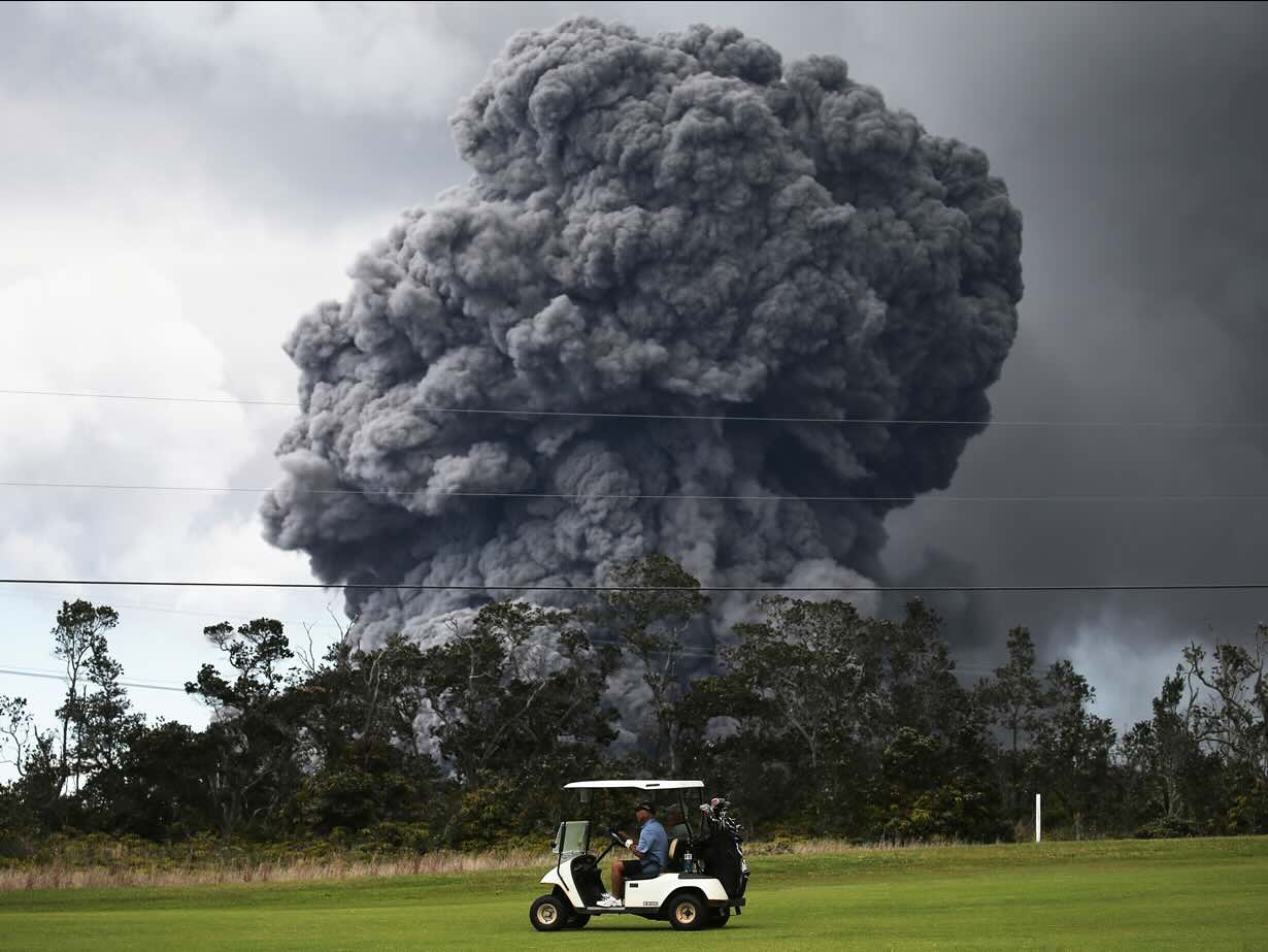
Volcanoes make for good sport. Golf comes to mind as an example: volcanoes can provide a great opportunity to improve performance. The summit crater of a volcano is conveniently large, greatly increasing the chance of a hole-in-one. It would look even better if the impact of the ball triggers an eruption, celebrating the win with a rising cloud and volcanic lightning. Volcano golf adds excitement to the tricky process of hitting a small ball with a big stick.
Even more exciting sports can be envisaged. The rule of thumb is, if you have thought about it, someone has probably tried it. Some sports are out of the running, however. The UK government in particular does not recognize cerebral activity as sport. Even though sport is defined as physical activity with a competitive element, the brain is not included as a physical entity in its definitions – meaning, no access to funding. (That went to extreme when a major school chess competition was forced into bankruptcy by the tax office. Perhaps out of embarrassment about this, after this the current UK government did fund the chess federation to promote chess in disadvantaged schools. Chess is cheap, after all.) So volcano-chess is out, sadly. (I was envisaging a speed-chess tournament in the caldera of Kilauea, timed for games to be finished just-in-time before the start of the next eruption.)
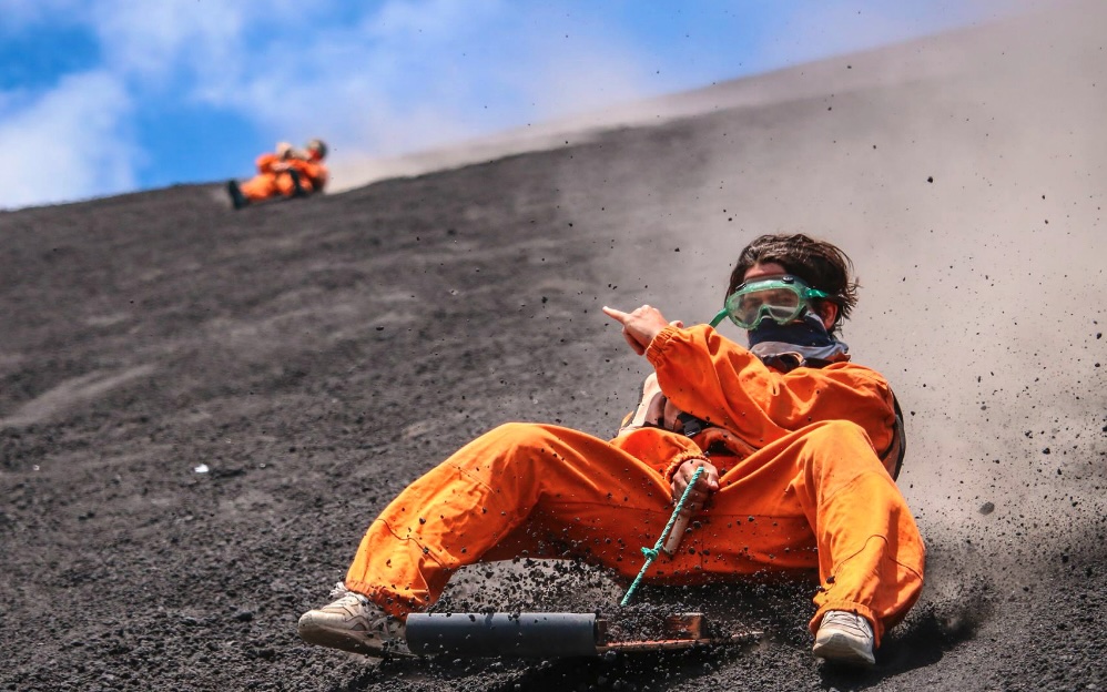 How about surfing? Not on liquid lava – that would not work. But there is in fact a sport for this, although it is actually called volcano boarding rather than surfing. The top location for the sport is on the slopes of Cerro Negro in Nicaragua (not the volcano in Colombia of the same name that Tallis warns us about). It involves sliding down the steep slope on a board made of plywood and metal, at speeds of 50 km/h or more – wearing lots of protective gear. To get to the start requires a one-hour drive and a one-hour climb, before sitting down on the board for a 5-minute adrenaline-filled surf down the mountain. A certain disregard of personal safety is needed, in part because Cerro Negro does erupt on occasion – it is among the most frequently erupting volcanoes in central America and the surfing is done on the ejecta of the 1999 eruption. (And if you think that chess would be a safer sport, you do not know what chess players are thinking about when staring at the board.)
Volcano skydiving, anyone? There is a sport for this. It involves ’wingsuiting’: this is variant of skydiving involving a winged suit which behaves more like an out-of-control airplane (a Boeing Max, possibly). (And whoever dreamed up that name missed an opportunity). It is dangerous enough at the best of time, but doing it above an active volcano takes it to extremes. So, of course, volcano wingsuiting has been done.
One person is known for wingsuiting into a volcano. That was done at Mutnovsky in Kamchatka. But as olympic sport, it has not caught on.
Cycling is an activity that can easily be combined with a volcano. Many volcanoes have good roads going up them (assuming the volcano does not erupt) and can be climbed on a bicycle. And if it gets too much, the way down is easy – as long as the brakes work. One of the biggest volcano cycle climbs is up Haleakala. (Not the biggest – there are several higher ones in the world.) But this is too easy for some.

The Rift
How about an off-road cycling challenge covering 200 km on lava and gravel, fording rivers and climbing hills? This is, of course, Iceland. It is called The Rift. The cycle route goes from the coast into highlands and back, circumnavigating the most unpredictable of volcanoes, Hekla – at least climbing it is, advisably, not part of the challenge. The race is on in July – but if you want to take part you are too late. It has sold out.
Running
The main volcanic sport (apart from eruption chasing) is running. (Not running away from an eruption, although the sport provides good training for that, might it become a necessity.) It involves running up and down the edifice of a volcano – a certain degree of fitness is required, as is a willingness to sacrifice future use of knees. These runs are proper events, with some competitors racing against each other and others just trying to make the finish.
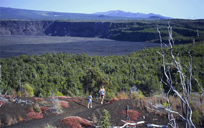
A famous example of volcano running was the Kilauea Volcano Wilderness Run, a full marathon that existed for 3 decades up to 2008 and typically attracted some 200 runners. The run started at the Kilauea caldera, followed the poorly marked Ka’u desert trail (competitors did get lost on occasion) and the Mauna Iki trail for 7 miles across the lava fields, before following the Pali road and the unpaved Escape Road (don’t ask) through the rain forest, back up to the caldera. The last half was all uphill. It was also possible to do a shorter 10-mile run around the caldera, on a route that followed the crater rim drive, the crater rim trail and Byron ledge – this shorter event was rather more popular and attracted up to 1000 people.
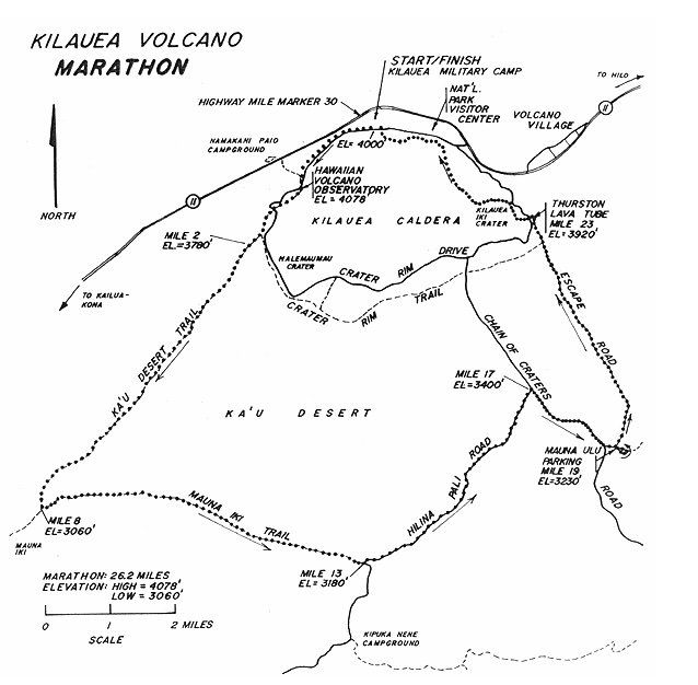
The last time this race was held was a few months after the opening of the new vent at Halemaumau in 2008, which required a rerouting to avoid the hazard of the sulfur gas emissions. It probably got too much for the organizers – the race ended after 2008 and was replaced by a far less volcanic half marathon in Volcano Village.
There are other runs, both marathons and ultramarathons, around volcanoes. There is one at Vesuvius, one at Pacaya (involving a turn-around at the top), one at Ruapehu (not running in 2024), and one at Villarica which promises a real lava lake. They have in common that they are gruelling, a volcanic punishment on the body, not for the faint-hearted and certainly not for the underprepared!
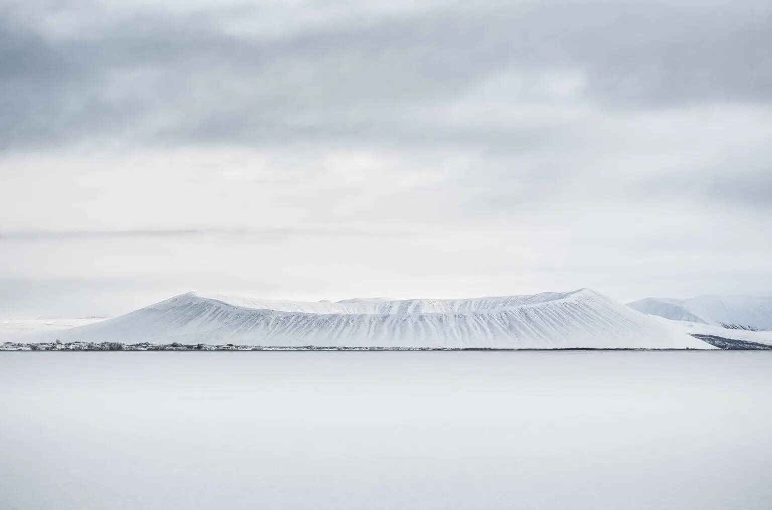
Of course Iceland could not possibly stay behind. There is an event in Iceland this August, involving a marathon and several shorter distances around Hverfjall crater. The advert reassuringly states that it is located far from the on-going activity at Reykjanes and that Hverfjall is safely extinct – while at the same time calling it ‘a hot bed of geothermal activity with geysers, hot springs, and lava rock!’. Hverfall is a wonderful tephra cone, 400 meter high with a large crater on top, a kilometer across. It is situated next to Myvatn, in the north of Iceland. The route includes circling the rim.
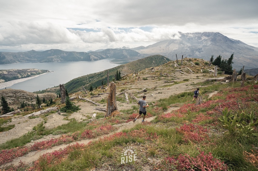
Or you may prefer running in the blast zone of St Helens. The blurb says that “with its sapphire lakes, rugged, toothy peaks and wildflower-blanketed slopes, the Mt. Margaret Backcountry on the northern blast zone side of the Mount St. Helens National Volcanic Monument provides an unforgettably unique, remote and beautiful trail race experience. The 50K and 20 miler offer big climbs, sweeping descents and stunning ridgeline views of the surrounding Cascade Volcanoes … High mountain lakes, rushing creeks and abundant wildlife dot the landscape, including resident mountain goats, elk, deer, bear, cougar, soaring raptors and many more.” I guess the bear and cougar will encourage fast running! As a final warning, “only attempt this race if you’re in top fitness, self-reliant and prepared for the challenge… this course humbles everyone who attempts it.”
For the extreme runner, there are many volcanic choices.
But there is one run to rule them all. It is an event with an evocative name.
Transvulcania
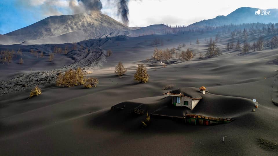
La Palma, one of the Canary Islands, was known for decades as volcanically safe. Yes, there had been an eruption 50 years ago at the southern tip of the island, but clearly nothing had happened since so that was okay. Until in September 2021, it happened again, with a destructive eruption when lava ran from the flanks of Cumbre Vieja to the sea, causing destruction in the villages in between. The eruption lasted for almost three months.
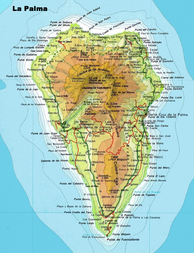
The island has a triangular shape. The wider, northern area is dominated by the extinct shield volcano Taburiente, with a deep rift on one side which is called the Caldera de Taburiente – but this isn’t a caldera, it is a flank collapse. The south side of this ‘caldera’ contains the remains of another shield volcano, Bejenado, much smaller and also extinct. From Taburiente towards the south, a ridge runs along the spine of the island. It is called Cumbre Nueva and Cumbre Vieja, where the two parts are separated by a small gap. They formed when, over time, the activity migrated southward. The ridge looks a bit like a fissure which got infected – especially the southern parts are badly pockmarked, looking like a bad case of the measles.
Cumbre Nueva, in spite of the name, is extinct. Cumbre Vieja is the only active volcano on La Palma. Eruptions happen every few decades. They occur mainly on the ridge, but can also happen on the flanks as happened in 2021. The eruptions tend to build up a cone: Cumbre Vieja is littered with them. The 2021 eruption added a new one to the already extensive collection. There are so many that the volcano has a hard time finding room for them all. Often, a new eruption accidentally coincides with an old cone, pretending to be an old cone which has re-activated while in fact it is the young taking the place of the old.
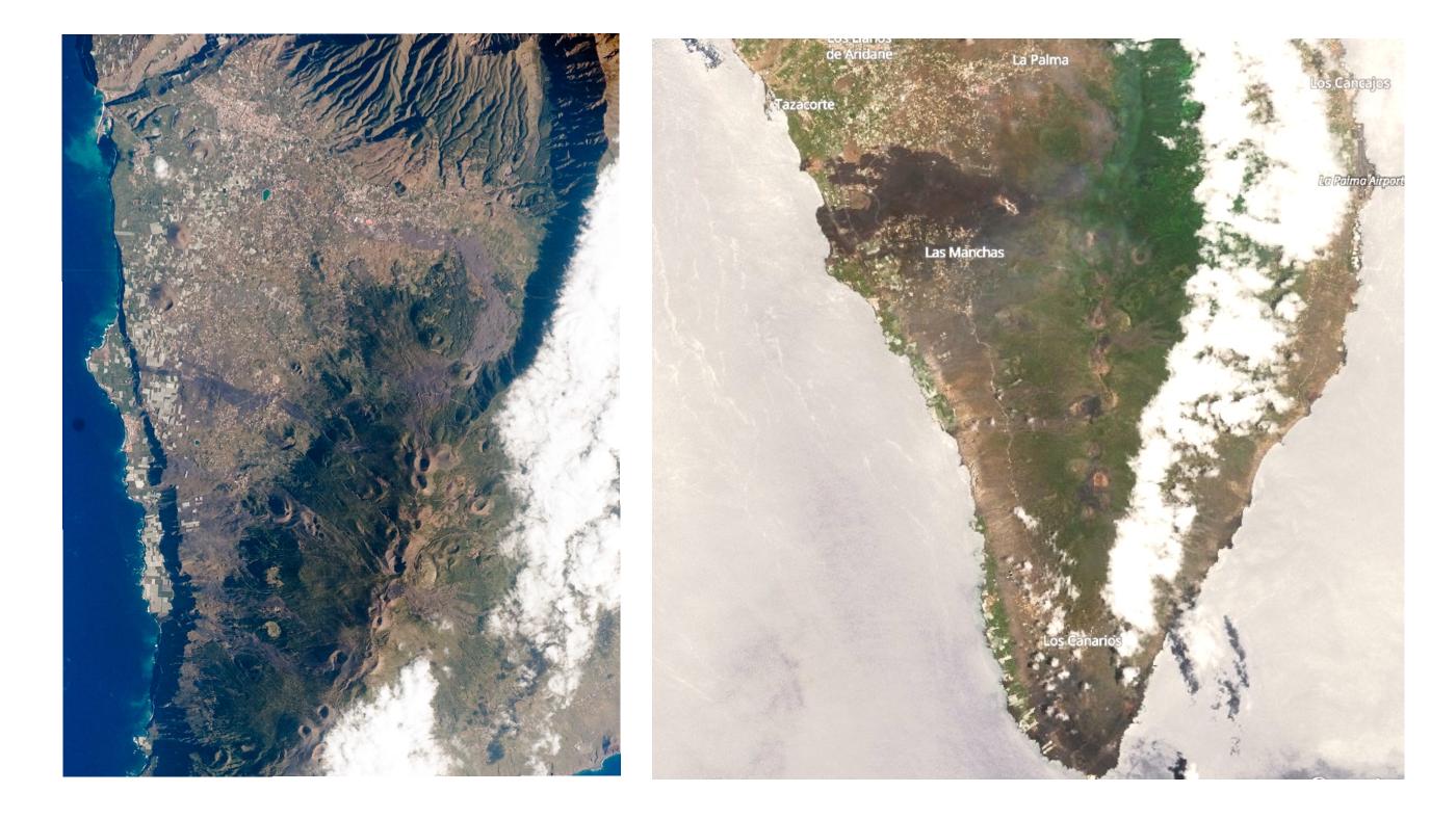
Left: Cumbre Vieja (below) and Cumbre Nueva (above) as seen from the International Space Station in 2008, showing the plethora of cones on the former. Right: A June 2024 Sentinel image of La Palma, showing the impact of the 2021 eruption
The volcanic history is complicated and involves five different volcanoes, as described in a previous post.
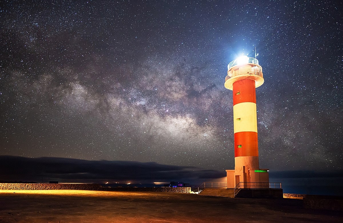 The running race attacks the La Palma volcanoes head-on. No skirting around the edges here. It starts in darkness, at 6am and appropriately at a lighthouse. This is Faro de Fuencaliente, near the southernmost point of the island.
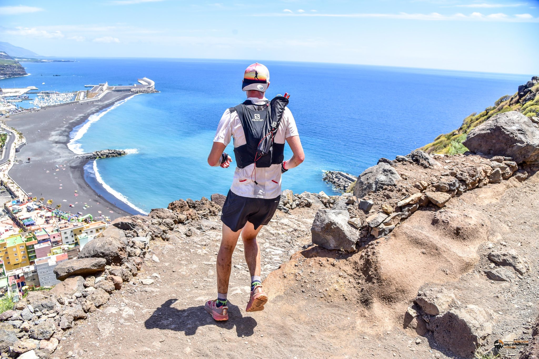
After 7 km and almost a kilometer of ascent (o, those legs) it reaches the town of Los Canarios. From here it continues the relentless climb, reaching the summit of Las Deseades at 17 km and 1800 meters altitude. Now the route descends 400 meters to El Reventon (if the full race is a bit much, you can also start just before this point at El Pilar and only do the marathon), before climbing up to the Pico de la Cruz (2300 meters) and the observatory at the Roque de los Muchachos (2400 meters) where the race comes past the Isaac Newton Telescope. You need to get to the observatory before 5pm or you will be taken off the course and probably get a talking-to about how this race is not for the poorly-trained.

Now the route turns to the southwest. A steep descent to sea level follows (the trekking poles the runners carry may be very useful here, in order to avoid accidents) at the Puerto de Tazacorte (o, those knees), and finally there is a 5 km stretch back in-land to the finish line at Los Llanos de Aridane, 340 meters high where crowds are waiting for the exhausted athletes. Arrive after 10pm and all will have been for naught as the race has closed. The advertisement talks about the incredible atmosphere at the finish line – which is true, this race is a national monument in La Palma. But after having been into the thin, cold air at the summit of Taburiente, any atmosphere will be welcome.
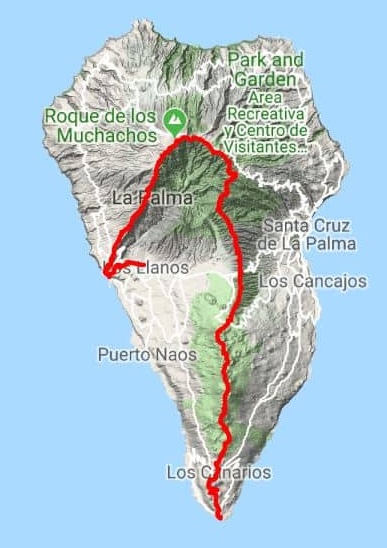 Is this the hardest ultra-marathon in the world? By the time they reach the finish line, the runners will have covered 74 km, have ascended 4.3 km and descended 4.0 km! (Just to rub it in, the finish line is 300 meters higher than the start.) The fastest runners reach an average speed of more than 10 km/hr.
What is there to see on-route? It is a volcanic landscape, getting older and older as the runners advance. One runner describes the scenery:
The first part covers a very volcanic terrain (beware of the ashes, it messes up the eyes). You then travel nearly 2000 meters of positive elevation differences in less than 20km. The second part is rather woody and wild. The terrain is more varied. It is an alternation of ascents and descents. Then begins the third part of this Transvulcania ultra marathon where the scenery is typical medium and high mountain of the French Alps… with a rather rocky terrain. After almost 50 long kilometers of continuous climb, I didn’t know the pain that awaited me: 2500 meters of negative elevation gain over 15 km! The last kilometers are done on concrete. It hits hard and it hurts a lot. Fortunately, at the end of the descent, the magnificent landscapes cheered me up. It was probably one of the most beautiful points of view of the race.
The runners first pass the cone of Teneguia, the location of the 1971 eruption. They won’t see much of it in the darkness, though! One tourist died here in 1971, after entering a closed-off area: the person died of inhaling toxic gas – one danger the runners don’t need to worry about. Next they pass the cone of Volcan de San Antonio, which erupted in 1677. After Los Canarios, the cones come thick and fast on the Ruta de los Volcanes (the Volcano Trail, which can also be taken in a more leisurely tempo, but not on the day of the race), barren ash heaps surrounded by pine forest: Martin de Tigalata (1646), Lavas la Malforada, the twin peaks of Deseada (the highest point of Cumbre Vieja), Hoyo Negro, and many others: there are some 120 recognizable craters along the 19-km long ridge. The Cumbre Vieja rift is a hot bed of volcanic activity, with eruptions occuring along its entire length.
Pico Berigoyo is the last (northernmost) cone on the ridge, before the route descends to El Pilar where Cumbre Vieja ends and the older (confusingly named) Cumbre Nuevo takes over. The visible volcanics ends now as the route continues into the forest. The Cumbre Nueva ridge began to be build about 700,000 years ago, with activity increasing over time. The eruptions ended after a brief phase of high activity, with a dramatic collapse. This collapse formed the Caldera de Taburiente, half a million years ago. By this time the runnners begin to feel as if they have been running for nearly that long, aging at the same rate as the landscape around them.
As the runners climb the old shield of Taburiente, the forest finally peters out and the alpine stretch begins, circling the collapse crater of the Caldera de Taburiente. The shield volcano started growing a million years ago and was active until 400,000 years ago. The rift of Cumbre Nuevo was part of this activity. The collapse of Cumbre Nuevo removed a part of Taburiente as well. The track winds up to the far end of the caldera, where the Roque de los Muchachos observatory is located. The edge of the caldera becomes very steep here, and a turbulent wind may come up from below. Now a steep descent begins towards the western coast. The route down is steep and rocky, but it provides a terrific view of the fertile plains of Los Llanos – if the runners have any energy left to lift the eyes up from the track. In the distance, the frightening lava flows from 2021 become visible. The black beach at the bottom takes its colour from the lava of Cumbre Vieja, taking the runners back to the young volcanics of the start, ages ago. This place feels like it should be the end of the run. But no, the run (or, by now, the crawl) continues for another 5 km through a dry river bed to the town at the bottom of the flank of Cumbre Nuevo, where the cheering crowds are waiting.

Volcanoes make for terrific sport. I am still open to the as-yet non-invented sport of volcano-chess. But clearly there is plenty of excitement around already. For the best few this is as participants of an extreme sport, while for the many others their role is as spectators and cheer leaders. And all the while, the volcano that provided the course looks on, biding its time to once again change the scenery.
Transvulcania is an exceptional event in this field. Is this really the hardest run in the world? It may well be: it is certainly a step up from the Park Run. Is it the most volcanic running experience in the world? I cannot judge – but if not, it must be running it close.
![]()
Albert, June 2024


Thx (the golf photo is insane). Also mesmerizing: The strinking contrast between the beautyful landscapes and the ugly sportsmen.
Being in a place like those, whether in a sport or just looking around, is exhilarating. I have had to spend time in deserts for work. You never stop looking at the scenery.
Volcanoes occasionally can do a nice Olympic Flame … one famous event on Hawaii is the Ironman. It has the route on the west side of Big Island. Worst volcanic risk is a Hualalai eruption
https://www.ironman.com/kona-community-course-maps
Kailua Kona is searingly hot all year around in noon ( at least at sealevel) and quite humid too .. high noon just after lunch yeilds over 30 c in shadow all year around even in deep winter. I found it extremely opressive after lunchtime at new years day. I guess that Big Islands lowlands lee side west are likey the worlds warmest all year around locale at latitude 19 – 20 its certainly quite sultry and gets the classification of a Tropical Moonsoon Climate
A olympic flame contest will be extraodinary hard in the heat and humidity of Kailua Kona.. but the road is also a few 100 meters up so at a cooler climate elevation and more suitable for sports
Kona side is souch an incredibley beautyful place! with the crystal clear blue waters and the tropical small town feel and mostly wild nature, a very relaxing and soothing enviroment .. peaceful is an absolute defenition there
Kailua Kona Is a tropical semi-arid climate, Köppen climate classification BSh.
You actually DID this, Albert?! Whoof. Runners are definitely a different breed.
I can’t help wondering if the floors of the outbuildings for the observatory on the left were/ are leveled to compensate for the incline they appear to be sitting on. Thinking of aching thighs, that incline could really do a number on ya by the end of the day. Not to mention the vertigo.
No, I am not a long-distance runner. Certainly no marathons! But I do know the observatory well. I have even been locked in at the Isaac Newton Telescope once when the weather was such that venturing outside was too dangerous. Yes, the buildings are carefully made level, in spit of being build on slopes. The telescopes themselves need to be sitting level, otherwise the pointing and tracking have difficulties. The domes might also have problems opening and claoing if they sit on an incline.
Neither I am a runner, but I guess it is the declines, i.e., the “negative elevation” that one runner describes in the article, which is worse than the inclines.
A couple of years ago at Madeira (to which La Palma is often compared to) I walked (just walked!) down this road, from the top to Calheta:
https://www.google.com/maps/@32.7532823,-17.1510474,3a,75y,259.64h,76.67t/data=!3m6!1e1!3m4!1sWBOqWdT5O0wzvgPYKkdOuw!2e0!7i16384!8i8192?hl=en&coh=205409&entry=ttu
and I got my thighs so painful (because I had to walk and also to _brake_ one’s speed at the same time, and the hard asphalt didn’t help), that I didn’t care to walk anywhere for a next few days.
Is it my imagination or is the rate of inflation at Svartsengi increasing?
The last samples are noisy. Impossible to tell any trend from them. I do think the inflation rate increased a bit after the eruption stopped, but it’s really difficult to tell.
I have been watching this, Merlot, there seems to be a resumption of the former inflation rate. See . Previously I had noted only a 63% rate compared to the previous, but was told to not jump to conclusions, but a glance at the GPS readings seems to indicate a resumption of the former inflation rate.
It’s a few days old now, but IMO published this beautiful interferogram demonstrating the ongoing inflation in the area:
Fagradalsfjall is until now without inflation?
If the current rate is sustained, rather than being a blip, it’s higher than that preceding the last eruption.
Thanks for a lovely article Albert. I must admit, as a passionate runner, I’m very tempted to enter the Icelandic race at Hverfjall. It’s on my bucket list at least, but unfortunately I’m not in shape for a marathon at the moment. Maybe next year if I can find some continuity in my training. You have my word that if (big if) I ever enter the race, I will write a race report as a VC article.
By the way, all three distances include the crater rim of Hverfjall, so the good news is that you don’t have to settle for half the distance, but you get to enjoy the full experience and still get to take the route around the rim! Yay!
Thanks for that correction! It has now been fixed in the post
On second thought, you can’t just join the race. International participants have to buy a 6 day guided tour package for 2500€. I’m not going to pay that kind of money to see stuff I’ve already seen before, just to be able to join the race. Bummer…
We must not forget this one, a true opportunity for the utmost exertion in fleeing the volcano. https://www.youtube.com/watch?v=aQtkoLxqUNQ.
Unzen too https://www.youtube.com/watch?v=V4_SaMgsO58
I remember seeing an old volcano watch on the Kau desert marathon, not the nicest place to run for so long in my opinion, way too much loose sand and gravel and erosion hasnt smoothed anything out. Its old for Kilauea but that lava was still only erupted 600 years ago, late Medieval. The average pub in the UK is probably older than the Kau desert 🙂
Some of it is less than 1 month old… And Kilauea has started swarming again big time, might get a proper resurface by the end of the week…
Really strange behavior at Kilauea this week. The crazy uplift on UWEV has stopped now, and the ERZ connector is quaking like crazy, 300 a day now is well within bounds to intrude. But there is no tilting at all from that direction as would be expected if magma was flowing that way, and the one exception where the ESC tilt jumped shows they are connected.
SDH is still uplifting too but not at a crazy rate, it has been higher recently. My best guess is that either magma is flowing downrift past SDH or SDH is now sitting right on top of the uplift so it isnt tilted by it. My best guess on why there are so many quakes on the ERZ connector and basically none on the SWRZ connector is that the past 9 months has seen all of the tension be removed, same as why we dont get much precursor activity to eruptions at Sundhnjukur now. Or why Hekla is quiet, there isnt tension on the rocks until magma makes a rush to the surface and it does it fast at all 3.
I have got a theory that the reason the ERZ seems to be blocked at the end of the connector is because the south flank of the ERZ and the south flank of the SWRZ are not really aligned, and they clash south of the bend. Its not really a real collision, but there is pressure, and it is notable that the strongest zone of south flank quakes is exactly here. Normally the ERZ wins this, or at least isnt affected, but the SWRZ is better connected with the summit and so strong summit pressure might also be associated with stronger push from the SWRZ too even without magmatic activity in the latter. I think this happened in the 1970s, Mauna Ulu was still open but it sits just about on that bend, the ERZ down from there was dead while intrusions happened multiple times a little uprift of Mauna Ulu, at the summit, and on the SWRZ. The inflation from 1970-1975 was not as intense as now but still very high and when the volcano was at its most full anyway, eventually the only option was to push through the ERZ connector anyway and shove the stuck flank – 1975 quake.
Its also notable that following large caldera collapses Kilauea erupts first on the SWRZ, in the early 19th century and now in the present day. The ERZ inflation before 2020 is a thing, but it stopped completely when the SWRZ connector first woke up in 2021, and has been dead since.
The summit has started deflating at the same time UERZ/Chain of Craters earthquakes skyrocketed. I think a pulse of magma has started moving into the deep rift under the Chain of Craters. The vertical magma body is rapidly dilating and fracturing the rock above. I don’t see clear signs of a dike intrusion, although earthquakes are indeed happening to the sides of the connector, so maybe there are some small dike intrusions in place already. Lately it has become difficult to distinguish dike intrusions from background rift inflation. I think the rules that applied in the past no longer do. I do expect that any time now, the swarming section of the East Rift Zone will snap and produce a sizable dike with maybe a small accompanying eruption.
Clearly, an eruption or non-eruptive dike intrusion is imminent at this point, maybe today or maybe in a week, and that Kilauea is now aiming for the Chain of Craters area, maybe Keanakakoi, or Aloi, or anywhere in between those two craters.
It is a bit of a stretch, but if you trace the fissure swarm of Pu’u Koa’e through the fault zone it does enter the upper ERZ area pretty close to where the strongest quakes are now. The eruptions are fed by a different branch of the system but I think as a tectonic structure the upper ERZ and the SWRZ seem to be continuous, while the faults and fissure swarms from Makaopuhi eastwards seem to start completely on the ERZ, and it is maybe not coincidental that these lower zones seem to have much more volumnous eruptions. Maybe it is down to similar elevation, the eruption on the 3rd was at about 1 km elevation and an eruption happening from the upper ERZ connector will be about this too, slightly higher even.There is also still the option it erupts in Halemaumau but that is not really going to alter the situations on either rift long term other than making it more likely to break out there next time…
I still think my idea of the SWRZ pushing enough to lock the ERZ might have merit here. The current swarm is intense but not breaking rock yet, I think the dikes on the SWRZ started after less than this, their intense swarms were caused by the dike itself not the precursors. I also think the 100+ microrad inflation at SDH isnt to be ignored either, its much more than set off the last intrusion from there, and if we are going into the unknown it might be a good time to propose that both areas could intrude together, with it being likely at least one erupts 🙂
But really, if the next intrusion is on the upper ERZ and it goes beyond the immediate area I might move my timeline for Pu’u O’o Jr forward by 5 years… The ERZ slept after 1965, with Kilauea erupting for most of a year in Halemaumau until 1968, then it went back to the ERZ within 2 months of that stopping and the vent that created Mauna Ulu was erupting within a year… A vent opening east of Pu’u O’o would need the ERZ to open fully and move the magma pressure from the summit to the middle ERZ, which might slow things down a bit, but if that happens within a year then we are looking at a new lava geyser and shield well before 2030, my original guess.
Yes, you are probably right with the SWRZ locking the ERZ. Both the connectors run southward when close to the summit, so the deep rifts under the upper rift zones likely face each other and are very close. Inflation of the deep rift under the upper SWRZ is likely to strangle the deep rift under the upper ERZ.
In this case, the large pulse/intrusion of magma into the SWRZ in August 2021 may well be the main reason why the ERZ has been relatively inactive for the past few years.
There is another element to that I hadnt thought of too. Kilaueas SWRZ flank is smaller but it also sits on Mauna Loa which has moved recently too. And the summit itself also pushes the flank and if you look at CRIM it has moved east much more than south in the last 2 years and especially following the eruption last September.
The summit is a caldera at the surface but it seems to have a preference to spread, and if uncontested it spreads in line with the SWRZ and directly at a right angle to the ERZ connector. The ERZ seems to be only able to erupt when there is pressure in the rest of the volcano, while eruptions at the summit are unconditional and eruptions on the SWRZ need only the pressure to push into the zone along the grain so to speak.
When the middle ERZ is open, from Mauna Ulu eastwards, it probably dominates the SWRZ and summit, and stays open as a result. Mauna Ulu was too high up and got taller than the summit leading to failure but when Pu’u O’o formed a bit lower the results are pretty obvious. It will be interesting if a similar eruption east of Pu’u O’o might be even longer or if it will be further away so less connected. Either way I expect at least a decade and 1 km3 of lava
How voluminous and what rate would you expect for a possible eruption? The intrusion January/February showed how much magma Kilauea can move in short time.
If ot imtrudes southwest like it did last time but with high intensity then maybe similar size to the last fissure eruption at Svartsengi, 20 million m3 in a day or so. Not a big eruption but very fast and lavaflows a l9ng way like 1974.
Eruption in the Chain of Craters maybe similar but possibly not this time around for a big eruption yet.
1974 had some pretty lava fissures, maybe it can do a Curtain of Fires there like Mauna Loa: https://www.nps.gov/havo/learn/nature/july-1974-eruption.htm
The PUHR GPS indicates that an eruption between Kaneakakoki and Luamanu crater is most likely. This GPS station moved sharply both south and east. So the most inflation/intrusion must be towards the NW from it:
July 1974 there was an eruption https://www.nps.gov/places/lua-manu.htm
I think that movement is coming from a bit more west. CRIM is moving strongly east but isnt really moving north or south. While AHUP is also being pushed southeast while also being further west than CRIM too. Most of the quake swarm is also a bit further southeast of PUHR too and it still doesnt show any deformation, but SDH and UWEV tiltmeters all stopped uplifting so magma is clearly going somewhere. I think maybe a very brief intrusion could have happened to offset the ESC tilt but it hasnt stayed open.
It would be handy if there was a functional tiltmeter further down the SWRZ, to see if magma was flowing down that way still and just in silence after what has happened there this past year. KOSM was good but it is basically in the graben from a month ago and offset a lot. So is probably going to be hard to read for a while.
Fascinating article Albert, thanks! At work I got talking with our lab’s mineralogist one day, about volcanoes and somehow Koryasky came up – the beautiful volcano just north of the main city in Kamchatka. He says, yes, I know it, I’ve hiked all the way around it three times. Wow! He was a very committed mineralogist…
The ultramarathon on La Palma reminds me of the Three Peaks Race here in Australia. From the linked wiki:
The combination of sailing with mountain running made it a race with a fair amount of coverage in the media, but sadly it ceased in 2013 after 25 years. Very tough! But it seems to me that the Canaries or the Azores would make perfect places for such an event, given excellent weather and actual volcanoes to run up to the top of!
The part-two of the interview with Þorvaldur Þórðarson about what he thinks about the Icelandic events has dropped:
Thanks for a fun and interesting article. At my age, it makes me feel wheezy just looking at these walks and climbs.
Icelandic volcanoes are so handy with their streaming live cameras and drone users!
Multiple earthquakes per minute along the Chain of Crater, visible on seismometers, in Kilauea volcano, right now. These are intrusion levels of seismicity, although I still don’t see clear signs of a dike intrusion. The area might be just about to snap.
The centre of inflation is close to the KKU seismometer (from the GPS measurements) and is no more than 1 km deep (because it no longer caused tilt at SDH, it is shallower than the distance to that instrument). An eruption just south of the caldera is one possible outcome. Of course the GPS data is always a day behind, so will not show the current development.
Would think at that point an intrusion up the ring fault is the easiest way. Which is a nice place for viewing although the chance it climbs the wall is enough being at Keanakako’i where I saw it might be a bad idea…
HVO has awoken an reported on the recent earthquake swarm on upper ERZ: https://www.usgs.gov/observatories/hvo/news/kilauea-status-report-upper-east-rift-zone-earthquake-swarm
Maybe one of the craters will soon get a lava lake? This would be a common eruption type there, if the eruption lasts long enough.
A category-4 hurricane is expected in the Caribbean tomorrow . Very dangerous and exceptionally early in the season
These TCs have been defying models and overperforming in intensification since 2017. Beryl just had one of the most rapid intensifications ever observed. It’s definitely going to weaken once it hits the eastern Caribbean but it does look like it’s going to enter the gulf which has been on track with producing a good number of rapidly intensifying monsters such as Ian. Hopefully the shear and dry air keeps a july disaster from happening.
Hawaii sits in warm seawaters ( sea 28 c in Autumn) and also haves very high humidity .. why are strong Hurricanes rare in Hawaii? I have sometimes wild dreams of a Cat 5 s insane rainfall attacking the old Halema’uma’u overlook lava lake surface
28C is not warm enough for hurricanes. The ones that hit Hawaii form much further east and if theyb get this far, tend to have already weakened quite a bit. Hurricane Ikini was the exception to this rule. It happened during an El Nino year. But mostly, hurricanes bring rain to Hawaai rather than strong winds. Flash flooding can do a lot of damage.
Limit for tropical cyclone development is 26 c I think and thats winter water temperatures in Hawaii, Air temperatures gets up to 30 c in noon everyday on the lee side
The Hverfall crater looks like a sibling to the craters of Honolulu (f.e. Diamond Head).
An ultimate mountain race would be a run from the beach to the peak of Tenerife on Teide, the highest mountain of Spain and a wrong placed Andes volcanic peak … it doesn’t look European or oceanic, but rather like a Andes volcano. The landscape also reminds more to Mexico or another Pan-American desert than Europe. This was historically the first step of Spain towards the colonial empire in America. On the way from the beach to the peak of Teide you can cross many climatic mountain zones from Subtropical to Tundra landscape.
More potentially extreme volcanic runs from sea level to summit are Mauna Kea and the Chimborazo. Indeed, the last one is likely the volcano with the highest slopes from the geographical environment.
I think a marathon up Mauna Kea would be borderline impossible, its not the altitude but the fact it is all uphill the whole way, for like 50 km or more, there are no downhills to recover and its always cold because of the plateau terrain in the saddle. Hilo is by contrast very humid and usually hot, I think running through such a contrast without acclimatizing could be dangerous even to experienced indivuduals. Even at Kilauea which is much lower than the saddle it is below 10 C in winter most nights and some days.
People have died up there from altitude sickness combined with exhaustion. I am aware of one case. It would be important to have spend sufficient time at altitude in the days before the event, in order to acclimatize. Any visitor (and worker) is required to stop at the visitor centre at the 3km altitude point for half an hour before continuing up. Being up there is not easy even without trying to do extreme sport. Add to this the state of the road beyond the 3-km (altitude) point which is unpaved over its steepest part and really requires four wheel drive (even though tourists do go in their rental cars, not entirely in agreement with the rental contract and every expensive if they get stuck). People do hike up from the 3-km point: it is around a 20 km return to the summit from there, on a track taking a different route from the road. Be aware you need to walk back as well – no bus.
How about a marathon DOWNHILL?
That would be unique…
You’re welcome to try…
I have been up at Mauna Keas summit and had no problem.. did that first day after arrival to Hawaii.. driving up to the summit.. I had no altitude sickness. It was an extraodinary sight seeing many 100 s of kilometers out to sea… a blue sea dotted with passade trade wind cumulus as far as you can see
You were lucky. I hope you did do the mandatory stop at the visitor centre. It is unpredictable and even a healthy person can get in trouble. For us, it seems random. Sometimes, no problem at all, at other times suddenly the altitude does affect you
Just walked around the observatory domes and the alkaline cinder cones ( where Andrea Ghez ) made her discovery of the central black hole of Milky Way, Mauna Loa was dark blue because of raileigh scattering, another pale blue dot was further north.. the boulge of hualalai… the sea was hazy and full of trade wind cumulus, sea full of floating popcorn a good sign of weak convection over the tropical ocean, Mauis light blue shape was also seen with a cumulus fortess on top of it… it was a lovely sight
I have had many great evenings and nights on Mauna Keas summit. Towards the evening you can see Earths shadow up there, Earths shadow cast itself on the lower atmosphere, the skies also becomes paler when the sun haves to shine through more atmosphere, towards the evening everything becomes soft up threre at Mauna Kea, high clouds floats across the sky until they merges togther at the horizon to form whirling swirling fiery, burning violet pink sunsets that are slowly silienced by the comming nightfall . Then, as if the sun had failed totaly in minutes, thousands of glistening galaxies are spewed out into night that comes so fast indeed in the tropics, night are lit by Kilaueas red dim glow if you stare down at Puna area = very beautyful
Reinhard Genzel I think was first with that discovery, and it was done at the NTT in Chile. Both teams got the Nobel prize for it though.
And in Kailua Kona you risks dying from heatstroke if you do the runn at sealevel , a place thats more or less as hot as the Equator all year around Kona side experience higher noon temperatures due to less cloud cover giving more insolation Kona gets very hot and yet having almost as high humidity as Hilo. All the Mauna Loa and Hualalai black lava flows from 1800 s also makes it much hotter than the other islands due to black surfaces heating up more. I been both in South Thailand and Kailua Kona in winter .. they where both as bad at noon
Still Kailua Kona is souch an incredibley beautyful place and likey having the worlds clearest seawater
Not soure if Hawaii woud be any warmer at all on the eqautor, there will be no dry side at ITCZ.. everything woud be as wet as Hilo
Canaries specialy Teide looks like the andean volcanoes due to arid dry climates and highly evolved magmas forming similar volcanic edifices and eruption activity. Teide indeed looks like some bolivian/ peruan stratovolcanoes that sit on thick crust with cream coloured evolved blocky flows, Teide is way more alkaline.. but evolved magmas results in similar landform morphology. I have have noticed that Cape Verde and Canaries are very dry while Azores and Hawaii are very green.. coud be that at Canaries and Verdes the cold seacurrents below a warm airmass forms a dry inversion cap and prevents convective rainfall. .. Ortographic rainfall seems also limited in eastern Canaries and most of Cape Verdes with cooler currents. While its very common in Hawaii and Azores that are very green … Hawaii thats the most tropical of all these benefits from its larger taller volcanoes and warmer oceans for more ortographic rainfall. Azores is wet due to low pressure cyclone belts
Here is some superfun experiments with Earths tilt! the imaginary results really is a radicaly alien planet compared to what we haves today in real life. I go for seapole for my own weather improvment. Hawaii, Canaries, Azores, Iceland, Galapagos, Reuinion woud be radicaly diffirent on these alternative Earths for soure
http://www.worlddreambank.org/S/SEAPOLE.HTM
http://www.worlddreambank.org/T/TURNOVIA.HTM
http://www.worlddreambank.org/J/JAREDIA.HTM
http://www.worlddreambank.org/S/SHIVERIA.HTM
What scenario woud Albert chose from? I myself woud go for seapole.. since Im always cold and feels sickly in cold wet conditions
Like the Canaries, also the Azores host the highest national peak … of Portugal: https://www.visitportugal.com/en/node/73819
It last erupted 1720, so is still a vital, but sleeping volcano. GVP judges the historical eruptions as VEI2. Small quantity, but maybe good quality to watch.
https://www.google.com/url?sa=t&source=web&rct=j&opi=89978449&url=https://pubs.usgs.gov/pp/1806/pdf/pp1806_report.pdf&ved=2ahUKEwj039Sxv4SHAxU6lYkEHbs1BRsQFnoECBoQAQ&usg=AOvVaw1Npuai4gODDfSuYMs471Te
Quite interesting to look back on Kīlauea’s history.
Zach
Thanks for the link. I have been looking at this older report to try to understand what is going on these days at Kilauea.
https://pubs.usgs.gov/pp/0963/report.pdf
Mac
Thank-you for the link, Zach! The active period of Mauna Loa was from 1840 to 1950, around 100 years. Does Kilauea’s active period last as long as Mauna Loa’s? If so, we might expect an more active Mauna Loa from 2040/2050 onwards and a more calm Kilauea.
I think they are a lot more random and variable than the easy alternation idea. There are definitely negative correlations over the historical period but not a blanket dominance. Its easy to forget that while Mauna Loa erupted some big flows Kilauea did keep an open lava lake nearly the whole time, and had some strong activity at times like 1918-1924 when Mauna Loa was mostly quiet. Lava lakes dont exist without a robust heat supply
And of course, Mauna Loa has also still erupted a full 0.9 km3 of lava in the present dominant period of Kilauea since 1950. The only volcano in Iceland to erupt more than that in the same time period is Bardarbunga, and its as much as Hekla and Grimsvotn erupted combined… And thats the volcano getting second pick of the magma, goes to show the different rules Hawaiian volcanism goes by, its crazy.
Before 1843 Mauna Loa was nearly inactive, maybe comparable to the long break between 1984 and 2022. 1843 was also one of the Maune Kea saddle eruptions like 2022. 1790-1840 were the decades, when Kilauea was very active, first to fill the caldera quickly after the 1790 collapse and second to do rift eruptions around 1823.
It would be interesting to know, when and how the activity level of the two Hawaiian volcanoes changes. Would we notice, if Kilauea begins to do less and Mauna Loa to increase?
Those are two of the most insightful Hawaii volcanism authors, in my opinion, together with Robin T. Holcomb. And that is probably the most extensive work on historical Kilauea volcanism. I have spent a lot of time in the appendices.
https://pubs.usgs.gov/of/1981/0354/report.pdf Here is good one from Holocomb.. one of his larger works
Holcomb for correction… yup the pioneer of Kilauea stratography
I have always said that there is no sport more suited to a volcanic venue than parkour, which I believe to be merely a refined version of the-floor-is-lava. Of course true volcano-parkour would have to include active flows of lava and would be for only the fittest, bravest, and best-medically-insured participants.
*PS KIDS DON’T TRY THAT AT HOME.
A volcano crater/caldera may also be a good playground for Baseball or European Brännboll https://en.wikipedia.org/wiki/Br%C3%A4nnboll
Fell running in the Lake District springs to mind. In 2020 Kim Collison did 78 peaks in a 24 hour period. I do half marathons and wouldn’t even attempt some of these – they look brutal!